Streetcars and Spatial Analysis.
What are your proposals for streetcars and or trolleybuses in Brooklyn and New York City? Here past trackage maps are presented and analyzed in todays environment. Geospatial analytical methods are discussed regarding new routes.
The listing below comes from List A-5 that was published on 4/1/1978 by the North American Trackless Trolley Association. The complete source is given in the rectangle below. NATTA has been out of existence for many years. When in existence, they published interesting articles dealing with trolleybuses worldwide. The list below is for North America and is very interesting. Note that it is as of 4/1/78. At that time, Toronto still had trolleybuses and so did Edmonton. Hamilton also had a small system. Chicago closed their system in 1973 and new system started in Guadalajara, Mexico. It is interesting to note that car capital Detroit and Los Angeles kept their systems to 1962 and 1963 respectively. More to follow. Thank you Mr. Porter.
The map below was produced QGIS and includes the contour type elevation file for New York City. As shown in other posts, there appears to be a line at 90 degrees in the western part of Brooklyn. The above map is a close up and I incorporated the street grid and subway stops and lines. Notice that the red "error" line crosses close to the 20th Avenue and 86 Street station of the "D" train ( West End Line) in Brooklyn. Notice the group of contour lines to the right (east) of the red line. I cannot explain it. In the future, I will add the "add on" elevation feature to explore that area.
A street view in Google of the area reveals a relatively flat area.
In the map above, produced by QGIS, I used the plug in tool to assign an elevation at any selected point. Notice the cluster to the left of the red bar. It is at Bay 25th Street and Benson Avenue. Notice that the elevation changes from 8 feet to 15 feet on opposite sides of the intersection. The contour lines appear to be incorrect. On the right of the bar, there are many contour lines but the elevation does not change that much. Something is wrong here.
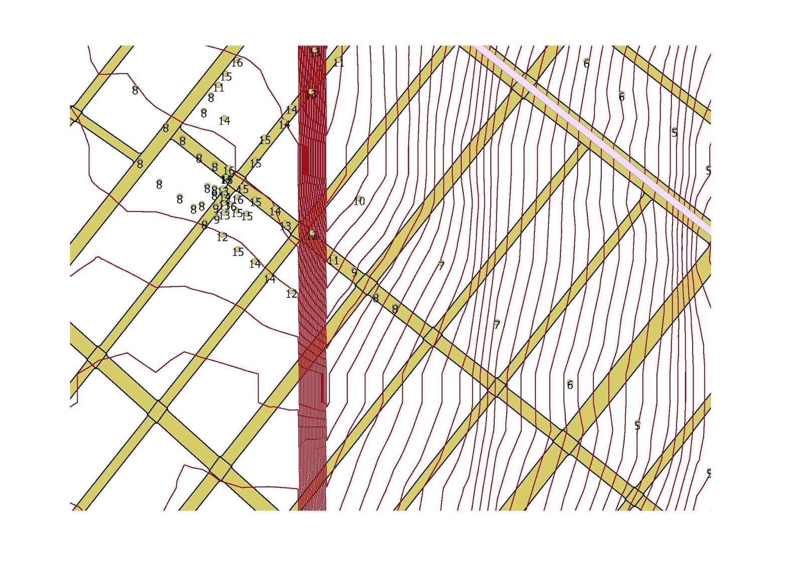
For several years, I have been posting in this blog several postings dealing with the elevation of various parts of New York City. Some of these postings are from a raster file, which is basically a aerial photograph of a land area. It is possible, through some mapping programs, to change a raster file to a contour picture, which shows a series of lines. The closer the lines appear close together, the slope increases. For some time, I noticed in one set of posts, a straight line that is exactly at 90 degrees to the bottom of the picture. In the frame below, this line appears not at the arrow, but near the intersection of the West End (D) and Sea Beach (N) routes in Brooklyn near 62nd Street and New Utrecht Avenue. It does not appear exactly at that intersection, but parallels the West End line structure to where it curves on 86th Street and continues south to Coney Island. This line stops at the water and continues at the same angle in western Coney Island. Using QGIS, I was able to activate an interesting feature that is able to assign an elevation in a map at any particular point. It is important to note, the this plug in is not getting the elevation from my raster or contour file but probably from the internet. In the second map below, the area around 79th street and 18th Avenue is shown in Brooklyn. The red vertical bar of many lines comes from my contour file and is the error. The numbers around the bar are elevations. The vertical red bar crosses either 18 or 19th Avenue at this spot ( I was too lazy to put in a label in QGIS to show the exact location). Elevations in the bar show no abnormalities in elevation. A street view inside the "bar"shows no major changes in elevation or structures such as a sunken highway or elevated tracks. So what is it? Probably an aerial photograph that was not joined together probably causing a "seam". The last map shows the "seam in black and white". Notice that it looks like a rapid transit line.
Philadelphia, a historic city that is not too far away from New York is a transit treasure. It has a subway and elevated lines, traditional streetcars, a streetcar subway, interurban style streetcar operations with trolley wire and third rail, and a large commuter rail system. Philadelphia, like New York, did get rid most of its streetcar lines, but the trolley subway may have played a roll in saving some lines. The Girard Avenue line was reconstructed and is currently PCC car equipped. Some traditional streetcar routes, such as #23 Germantown Avenue are now bus operated even though SEPTA told that this bustitution would be temporary. I am told that in Northern Philadelphia, some wire is still up and some track segments remain. Philadelphia has also three trolley bus routes in North Philadelphia that are still running, but the two abandoned routes in South Philadelphia (Snyder and Tasker Morris) still have wire up.
I used Google to take a tour of the Snyder Avenue Line. I punched in at random an address on Snyder Avenue and I got the following shot:
This is at the western end of the line. I believe that the route turns on 29th Street. This is a one way loop with wire still up. What do I see in the background,.... is that a gas tank?
I started to follow the street but the street ends and there is an expressway and the river with a name that is hard to pronounce. Somehow, I Googled across the river to Passyunk, which is a historic town and near S. Newkirk Avenue, there is a baby gas tank, at least as of a few years ago. Incidentally, the trackless trolley wire on Snyder is in bad shape. I am not sure when the line was abandoned "temporarily". From other sources, unfortunately, the trackless trolleys are difficult to operate and SEPTA is not to happy with electric surface transit, as I glean from subchat.
Sorry for the quality of the pictures. The gas tank and its lattice support is probably large because it was visible from the trackless trolley loop which is quite far away. More to follow on Philadelphia.
Below is a recent news study about Philadelphia transit.
I came across an interesting web site that deals with some of the material found here but in a more historical fashion. It is called Ephemeral New York https://ephemeralnewyork.wordpress.com/.
I came across an interesting map from that site. I was not able to get the source but it seems to be an early map of the City of Brooklyn in 1766-7. At that time, what is now the borough of Brooklyn, consisted of a number of small towns, some dating back to early Dutch settlement. Then, the town of Brooklyn was around the area nearest Manhattan (New York) and consisted of the area of present day downtown Brooklyn and Red Hook. The map was truncated so I could not get the names of the owners in the legend.
This is the map posted in Ephemeral New York. There does not appear to be many streets except the "Road to Flatbush" and the "Road to Jamaica", which were towns further to the east on Long Island. The road to Flatbush probably became Flatbush Avenue and the other road to Jamaica may have become "Fulton Street". These road split as shown on the map and will become an important point to georeference using ARCGIS. It is interesting to note that on this map, surveyed in the years 1766 and 1767, elevation was taken into account on what appears to be hills. On this map, the hills appear to be brown and have a contour appearance, like a modern contour map.
Using Adobe, I transfered the above map from a xxx file into a TIFF file, which is a raster file in ARCGIS. Using a modern street grid of Brooklyn ( from Bytes of the Big Apple), I started the georeferencing process. Notice from the old map the the coast line is not the same as we have today. Apparently, there have been much landfill in the past 250 years. Acting very fast, I did no research on the points listed on the map to get a more accurate overlay, but I did use one point on the old map where the road to Flatbush splits off from the road to Jamaica. This is the Flatbush Fulton Street intersection. The modern streets today may not be in the exact location shown on the map 250 years ago. I also picked a point near Wallabout Bay and crossed referenced it on a modern map since the shape of the coastline appears the same. I also picked an arbitrary point on Governours Island as well.
Notice how the resultant georefeneced map is distorted. In the base ARCGIS map, I brought in the modern subway system and stop file and the street grid. The results are not perfect but shows on the 1766 map where the modern street grid may fall, perhaps.
I noticed that the "hill" areas on the 1766 map appear somewhat accurate. One way to test this is to bring in a modern contour map and see if the concentration of contour lines really correspond to a hill on the 1766 map.
In this frame above, the hilly areas are show by a concentration of dark lines. It is hard to see the original hill drawings on the 1766 map so I lightened the contour lines by changing the display percentage.
Generally the increase in slope shown by the contour lines on the modern map corresponds to the hilly areas shown on the 1766 map, even after 250 years of development on the surface.
Although not shown on the subway map above, but the street elevation at Bergen and Smith Streets is 24 feet ( this will need to be verified ). This station may have had a water condition that resulted in the closing of the lower level (Express) platforms. This area may have been adjacent to the Gowanas Canal but the elevation is high. This will be discussed later. Thanks folks: Tramway null (0).
I revisited QGIS again, that GRASS related geo-spatial software. It is possible to bring in previously created or used raster and vector files into that environment. There are many advanced features that I did not try yet, that the no-frills ARCGIS software does not supply. In QGIS, you can take a raster file and make contours; something that you cannot do in ARCGIS without buying a more expensive package.
In this QGIS map, a NYC raster file was brought in and converted to contours. A vector subway map (stations, lines and RR's) was also added. The arrow points to the area between the Culver and Brighton Lines in Brooklyn along the Bay Ridge RR cut/ The map is able to show the open cut (change of the elevation) around the area. The contour lines are very crisp and easy to produce.
A closer map of the area. The arrow points to the location where the Culver Line on McDonald Avenue passes over the Bay Ridge Cut at "Stop and Shop". Produced in QGIS using Bytes of the Big Apple and other sources.
This interesting map was produced using recent NYC flood zone information, the street grid for Staten Island and a contour map produced in QGIS from a NYC Elevation raster file. I was surprised to see that the RR for the northern shore of Staten Island at this point is more inland as one goes west. These three maps were produced using QGIS, is a free online software.
Tomorrow in France I believe a big conference will be held dealing with the environment and climate change. Transportation will be discussed. I hope they consider, what is called the "Transit's Stepchild", namely the "trolley coach" as part of a solution to surface transportation pollution.
This picture was taken from www.nycsubway.org and was taken on 4/18/59 by George Contrad. It shows a BMT work train with AB Standard Cars on the elevated portion that approaches the Williamsburgh Bridge in Brooklyn on the Jamaica Line. Several trolley coaches are shown as as well. If you look closely under the el, you may spot a twin shrunken street lamp as well. What a great picture.
This photograph comes from the New York Public Library Archive and is probably from 6/1/37 at Greenwich and Courtland Streets in Manhattan. The New York Public Library has a nice digital archive for New York City and this photo comes up when you click a dot that is located near the footprint of the former World Trade Center. Lower Manhattan for centuries was made up of narrow streets and small blocks with multi-story buildings. Under urban renewal, the old streets and buildings we redeveloped into what is called "super blocks". It is hard to believe that nothing in this photo exists today. In the 1930's, streetcars in Manhattan started to be converted to bus and to make work, the Work Progress Administration started to remove the trolley tracks. Notice the conduit track which is typical for Manhattan street railways. The Ninth Avenue Elevated probably stopped service a few years later on 6-1-40. The new Eight Avenue subway, opened nearby in the early 1930's, with stations in the area at Broadway-Nassau (Fulton Street), Chambers Street (at Church Street) and Hudson Terminal (on Church Street near the present site of the World Trade Center at Vesey Street. the northern border of the former World Trade Center. The IRT 7th Avenue Line passes directly through the site at Greenwich Street, I believe the same street shown above. Many parts of New York City do not look like what existed 70 years ago and I think everything in the picture does not exist now. I believe that the area used to be called "radio row" because of all the electronics shops that existed then. The area called TRIBECA, which is on the west side of Manhattan above Chambers Street is very fashionable now but as late as of the 1960's, that area has a lot of lofts and the shoe industry was located there.
The next photo comes from the same archive and is dated 7/1/33 by P.L. Sperr. It is a the intersection of Fulton and Greenwich Streets and is facing west towards the Hudson River.
From this photo, you can see that Greenwich Street had the Ninth Avenue El and the IRT 7th Avenue Broadway line as well (see the subway entrance with the two globes). This intersection is well within the WTC present complex and does not exist today.
Today is the 59th anniversary of the end of regular streetcar service in Brooklyn on October 31, 1956. Yesterday was the 61st anniversary of the extension of IND "D" train service to Coney Island via the Culver Line. These two events intersect spatially at the area of McDonald Avenue between Cortelyou and Ditmas Avenue. When the Transit Authority pulled the plug on the Church Avenue Line on that date, McDonald Avenue streetcars and Church-McDonald lines also died. Since there are a lot of electrical connections of overhead wires at this spot, the first trolleybus line in Brooklyn, namely the Cortelyou Road Line (B-23) also died. Electric trolley bus service would last several more years in other parts of Brooklyn until July 27, 1960. In the picture above, taken from Dave's Rail Pix, shows a southbound 50-McDonald streetcar on McDonald Avenue near the Church Avenue intersection. The car is bound for Coney Island. On the right of the car is the Greater New York Savings Bank and a US Post Office. At the focal point is a hill that has Greenwood Cemetery on the left. At the crest of the hill was an early trolley barn that was involved with the research of the PCC car in the 1930's. Today the hill has a large transmitter for Bishop Ford High School.
I miss these forms of surface electric transportation deeply. I think that if streetcars would return to Brooklyn, they would opt to be wireless using a new technology. They will not be the same. It is the wires and sparks that make trams and trolleybuses fun, in my humble opinion. Also, I cannot document this, but I read that there were original plans to end Culver Line service between Ditmas Avenue and 9th Avenue on October 31, 1954. Service would have been provided by diesel bus. If this occurred, myself and others would not have had the joy to ride the Culver Line between 9th and Ditmas Avenue. It was thought that rapid transit service was not needed between these two points once the Independent "D" train was extended to Coney Island. I believe they are very wrong and the area needs rapid transit today.
The above map was produced in ARCGIS and shows a familiar area posted before in this blog. It shows the area around the 38 Street yard in Brooklyn where the West End and former Culver Lines meet. This area is the site (across 37th Street) of the historic Greenwood Cemetery. where many famous people are buried. This is a rich site with the 38th Street shops and yards on the upper level and various mysterious ramps and underpasses on the lower level. In the map above, elevations are in feet and this is a very hilly area. To produce the present layout, many thousand of cubic feet of material had to be extracted out and this took many years around 1914. In the above map, NYC subway routes are shown as a red line and a Railroad shape file, supplied by DOITT (New York City Department of Information Technology) is shown in blue. This general railroad trackage can refer to surface railways or non revenue tracks. If you look closely, you can see that one set of RR tracks curves at the 37th Street - Fort Hamilton Parkway intersection and goes to what appears east to McDonald Avenue. Also, there is a track that goes south on 37th Street south of Fort Hamilton Parkway. This was true until the 1980's when South Brooklyn service was stopped along 37th Street and McDonald Avenue.
It is ironic that railroad trackage was shown on Fort Hamilton Parkway next to the cemetery. In the late 1880's, there were plans to expand various surface steam railroads from 37th Street east to Flatbush or East New York / Brownsville at this point. ( See NY Division Bulletin, ERA, Vol. 18, No 1, February 1975, p.5-6. These surface steam railroads were never built. In addition, if the City of New York had the money, the Independent Subway would have been extended from the area around the Fort Hamilton Parkway station and along Ft. Hamilton Parkway to Bay Ridge and eventually to Staten Island. If this second IND system was ever build and the Culver Line existed, the Ft. Hamilton Parkway station at 37th street would have been a busy one in deed.
This article appeared in the "Greenpoint Weeky Star" on Friday August 10, 1962. This paper covers the northern part of Brooklyn called Greenpoint, which has since along with Williamsburg, have become quite fashionable. In my blog, I occasionally write about what was called elsewhere "New York on the Eve of Bustitution", showing how New York, specially Brooklyn looked during the period from around October 31, 1956 to July 27, 1960 and beyond, as electric surface transit was destroyed in Brooklyn and parts of Queens. When the last trolleybus ran on July 27, 1960 and the last South Brooklyn Railway electric locomotive ran under trolley power in 1961?, the wires and poles did not disappear the next day. The poles and wires were up for many years. Too bad that they did not make it to 1969, the birth of the environmental movement. I could not bring in the article directly, but here is what it said on page 3:
The last reminders of a by-gone trolley car era are vanishing from the streets of Brooklyn. Borough president Abe Stark announced today that more than 5,000 unused trolley poles and miles of overhead wire are being taken down. The work is being performed under contract and represents another part of a borough -wide community improvement program sponsored by Stark. He announced that preliminary work has consisted of the elimination of 95 per cent of the overhead cables. The contractor is expected to step up the actual removal of trolley poles from 30 a day to 100 a day. The improvement project calls for the removal of poles on 27 or more main streets and avenues. It is estimated that 1,825 tons of steel poles and 325 tons of overhead wires will be cleared from the borough's streets when the work is fully completed. The poles and overhead wires were essential parts of an extensive trolley car network that crisscrossed Brooklyn during bygone generations. As many as 80 trolley car lines and shuttles were still in operation in 1919, according to records of the Transit Authority. The last of Brooklyn 's trolleys were discontinued in 1956 when the Church Avenue and McDonald Avenue lines made their final runs and buses were substituted. The City Budget Director reported in January, 1962, that the Transit Authority had rendered jurisdiction over a number of discontinued trolley and trolley coach facilities to the Board of Estimate. The board subsequently approved a proposal by Stark for the removal of poles and wires. Historical records indicate Brooklyn's electric trolley car era had its beginnings nearly 75 years ago.
End of Article.
Comments:
The article did not tell us that the date of the last trolley coaches (trolleybuses) was July 27, 1960. In my humble opinion, by August, 1962, most of the poles from the older streetcar lines that were destroyed from 1945 to 1951 were gone. Poles had to be removed then from the
Church Avenue, parts of McDonald Avenue line and perhaps the Coney Island Avenue Line. The five or six trolley bus lines had to have there wires removed, including the Cortelyou Road line that also stropped on October 31, 1956. According to info of the New York Division of the Electric Railway Association, pole and wire removal lasted until 1965 were these items and troughs were removed on former South Brooklyn Railway trackage under the Culver Line and the area between Fourth Avenue and the harbor. Some of the wires went to the Branford Trolley Museum as well.
In northern Brooklyn, the base of the quoted newspaper, many trolleybus lines ran and were eliminated around July 27, 1960 and thus this was their interest in the remaining wires and poles in that district.
Very few trolley poles remain in Brooklyn. Yes, several can be found and they are isolated. Some can be found near former streetcar, trolleybus turn arounds and along some subway right of ways. Surf Avenue in Coney Island has a set of poles on both sides of the street just like in the old days. They are painted but how long will they last? Even cast iron melts away after so many years.
This digital image comes from the New York Subway Museum Archive and is dated October 3, 1950. The photograph was used in connection with contract T-11 which involved bringing the Independent Subway to Coney Island via the BMT Culver Line. This view is on McDonald Avenue facing north. The car is on the west side of the street just as the Culver mainline structure turns northwest. You can see the girders that do not have tracks yet on them approaching the decline to the Church Avenue Station. Unpaved South Brooklyn Railroad tracks are in the middle of the street and are used by McDonald and McDonald-Church streetcars.
The above map now shows the location of the PRW of the Flushing Line extension. The station at 34th Street, 11th Avenue is also shown and I should have made the green dot bigger. You also see neighboring transit lines and stations and the street elevation. This update regarding the station and line shape files comes from our friends at: "Center for Urban Research at the Graduate Center\CUNY". There are also very interesting maps at this location, not all transit related. Incidentally, the Flushing Line passes at 90 degrees across the former lower level of the "Eight Avenue Subway" at the 42nd Street station. I am told that there is no visual links between these two systems. As a transit buff, who has weird ideas, my idea would have been to have the Flushing Line have a branch off to the north end of the 42nd Street 8 Avenue Lower Level station. From an engineering point of view, I do not know how much space would be required to make such a branch off. Some westbound Flushing trains would use the lower level track to meet with the mainline Eight Avenue Tracks. The final stop would be 59th Street - Columbus Circle. The problem would be signaling for this section and the small width of Flushing Line Cars. Not all Flushing trains would go to Columbus Circle. You also have the problem of relaying and not blocking downtown IND trains. Of course, would there be a need for such a service from Flushing to Columbus Circle?
Also, the proper trackways and switches must exist to allow the trains not to return back to Queens via the 53rd Street tunnel.
Tramway Null(0)
Last Sunday, a new subway station opened at 34th Street and 11th Avenue for the # 7 Flushing Line. This extension is about 1.5 miles long and does not include an intermediate station. There has been some talk on Subchat about the elevation of the area. I was not able to obtain a shapefile containing the new extension. I believe the tunnel built is continuously downhill . Please see the map attached:
In this map, in which the subway extension is not shown, the Flushing line ends at 41st Street and 7th Avenue (short purple line). I placed a label " 34th Street - 11 Avenue" on the map at the general location of the new station. The elevation contour layer is measured in feet. I also brought in a map of the Hudson River (yellow) without listing the depth. The range appears to be approx. 62 feet to 15 feet at 34th Street. It is a little difficult to read the altitudes, I should have made the font bigger!
Someone in subchat brought up the link below dealing with trolleybuses and tram cars in London, England. These pictures, from London newspapers are very interesting showing various double deck trolleybuses and tram cars. Interestingly, many of the shots of tram cars are from the central business district of London where cars received their juice from middle of the track conduits. I remember seeing a London transit album as a child showing a tram subway in central London called the "Kingsway" subway and sure enough, some cars are marked as such. Sorry that I could not bring up the pictures. One picture struct me very much; Sorry that I could not do a better job in bringing it up. I had to paste it via word and change it to jpeg file via Adobe. In this picture, from a London newspaper shows a double decked bus (left) and on the right, a double decker tram car without wires. The date is 1950 and it is at noon when a strange snowstorm struck. If you had a better picture in front of you, you would see the mist and water on the front and side windows of both vehicles. There is snow on the ground and the streetlamp is similar to the ones shown in " A Trip to Prague, 1960".
This scene is very similar to a drawing by Spruance who painted urban scenes. The Spruance drawing is from the 1930's and probably shows a Manhattan scene. It may be Philadelphia because Spruance comes and drew many Philadelphia scenes. Looking at both double decker buses in both drawings, shown at night ( really noon in London ) leaves an interesting impression. Even the foggy windows are about the same.
I am a lazy person and I did not do recent research, but I would guess that London abandoned trams around 1952 and trolleybuses probably around 1960. Unlike New York, London was able to free itself from anti-tram feelings and eventually built a modrn new tram line in London.
I came across this article in Subchat by chance. I never knew that Louisville had an early elevated line. It was not just a structure for steam trains to pass through a city but a regular line with a schedule. First run with stream trains, it was later converted to overhead trolley. Several cars ran together. The tall pole in some of the drawings below are early arc lights that lighted the waterfront. What an interesting article. Louisville may have had also a trolleybus system that was unique, it passed between two states. I may have read something about this years ago in an article published in the North American Trackless Trolley Association. I read the article very fast, and I think the system folded in 1907? Sorry for the truncation. See link in Subchat.
LG&E photo–ca. 1922, Power Station, Riverfront and Elevated Line
12
shares
Share on Facebook
Share on Twitter
+
What's This?
[ Editor’s Note: Ron Schooling is an avid transit enthusiast and is working on a book detailing early mass transit in Louisville. He has contributed to Broken Sidewalk several times in the past including our recent look at road conditions and the desirability of transit a century ago. This is his first guest article following up on transit related issues. ]
How does one actually start with a topic like this? Could this have ever been a reality? Well, the answer is a resounding YES!
American history is very quickly forgotten, especially when all physical vestiges, remnant structures, scant photographic images and text references, along with a plethora of other scattered, isolated bits and pieces of information are widely strewn about everywhere. This makes the quest for clarity like glancing at a gigantic tabletop puzzle in a pile. The picture is obviously there somewhere but unavailable until put together. Scattered materials make a nearly impossible task for casual readers, as well as for history buffs and even experts. A straightforward source simply does not exist.
When starting my search for incontrovertible proof that our El trains existed, I had no idea how widely scattered the information bits would be. Over time, the pieces eventually coalesced revealing a fascinating picture of our advanced and modern trains of 116 years ago.
Millions of Louisvillians commuted on these trains, thought of them as an inherent lifestyle and a birthright, enjoying all the benefits of this big-city transit. It was an every-day commonplace experience enjoyed and heavily utilized by everyone. One we would like to have in place today but sadly this level of service will likely never return.
The physical elevated structure was a twin-tracked line stretching 4.11 miles from 1st St. in Louisville, to Vincennes St. in New Albany.
On the return leg from New Albany, after crossing the Ohio River, over a mile of the line in West Louisville was on elevated wooden trestle. After 23rd Street, the line followed the edge of the Portland Canal to about 14th Street. From there it re-elevated on steel uprights for its final 1.5-mile stretch along the Ohio riverfront of downtown Louisville. Passenger boarding platforms were 100 ft. to 200 ft. in length. The wharf area was interspersed with three purpose-built elevated commuter stations that averaged 15 to 20 feet above ground with steep stairways located at 7th Street, 4th Street and 1st Streets.
Looking West at Central / 7th St. Station – the electric passenger waiting room was right next to the Ohio River with steep stairs down to the wharf. Passengers could also use the main station for access to other trains.
Mention of Louisville’s El stations is very important in the legal definition sense. Merely running a passenger train atop an elevated structure does not classify it as an El system. Trains must travel between multiple El stations to constitute a true system like New York or Chicago. Those extensive lines are incomparable, yet the Louisville system although small, was in every sense a bona fide and genuine El.
A westbound train departs 4th Street Station after having just arrived after a one-minute trek from First and Water Street station, now the middle of the Witherspoon parking garage. The scene pictured below is at Fourth and River Road, just below the Galt House hotel’s turn around loop, next station is 7th Street aka Central Station.
Above 1890s lithograph from author’s private collection.
These commuter trains atop the elevated were organized and operated as a mass transit, intercity commuter rail system. With trains atop heavy rail, 15-minute headways, total grade separation, and intersection free elevated routing, it was clearly a “Rapid Metro system.” The K&I Bridge Companies elevated line electrified two years ahead of the famous Chicago “L” trains, and set record breaking other firsts in the nation and world of electric rapid transit. See Citations below the next train photo.
Louisville Wharf toward Fourth Street circa 1905, Kentucky Historical Society.
In every possible sense including legally defining terminology, these were not mere trolleys atop a trestle. These were multi-unit train sets, with purposeful rail line design, boarding commuters at multiple elevated stations on twin-track standard 4ft-8.5in. gauge heavy rail.
The downtown section presented a true big-city urban streetscape; darkened streets between the steel uprights were busy with street traffic, while the rapid transit and other trains scurried simultaneously along overhead. It was an urban area, with a dark and gritty feel especially where an upper and lower Second St. prevailed.
How about a fast train coupled with a rowboat ride, simply to make it to the work on time? Occasionally the Ohio River would prove unruly, with commuter passengers arriving to temporary rowboat service at their stations. The trains still ran on regular 15-minute schedules, but getting to and from the stations sometimes proved slightly out of the norm, but K&I commuter service was never closed due to high water.
Fourth Street at wharf during flood circa 1902. (Kentucky Historical Society)
The electric arc lights mentioned above were very powerful Victorian era equivalent of the tall cluster lights now lining our major freeway interchanges. These vastly improved passenger safety and security for steamboat wares stored overnight on the wharf. The basket [device] far up the pole was similar to a cherry picker, to enable changing of the carbon arc rods. This lighting system was scattered all along the entire riverfront. The K&I Bridge Company’s earlier steam version commuter trains ran from 5:45 am until 2:30 am, nearly 24/7 and these powerful lighting systems were an absolute necessity along the wharf.