Dear Visitors:

Please scroll down the page to see present and archive blogs.

Thank you very much: Tramway Null(0)

Webrings - Maps - Trolleys and More

Navigation by WebRing.
Showing posts with label Georeferencing. Show all posts

Saturday, December 5, 2015

GeoReferencing a 1766 Red Hook and Downtown Brooklyn Map


Hi Folks:

  I came across an interesting web site that deals with some of the material found here but in a more historical fashion.  It is called Ephemeral New York  https://ephemeralnewyork.wordpress.com/.


I came across an interesting map from that site.  I was not able to get the source but it seems to be an early map of the City of Brooklyn in 1766-7.   At that time, what is now the borough of Brooklyn, consisted of a number of small towns, some dating back to early Dutch settlement.  Then, the town of Brooklyn was around the area nearest Manhattan (New York) and consisted of the area of present day downtown Brooklyn and Red Hook.  The map was truncated so I could not get the names of the owners in the legend.

  This is the map posted in Ephemeral New York.  There does not appear to be many streets except the "Road to Flatbush" and the "Road to Jamaica", which were towns further to the east on Long Island.  The road to Flatbush probably became Flatbush Avenue and the other road to Jamaica may have become "Fulton Street".  These road split as shown on the map and will become an important point to georeference using ARCGIS.  It is interesting to note that on this map, surveyed in the years 1766 and 1767, elevation was taken into account on what appears to be hills.  On this map, the hills appear to be brown and have a contour appearance, like a modern contour map.

Using Adobe, I transfered the above map from a xxx file into a TIFF file, which is a raster file in ARCGIS.  Using  a modern street grid of Brooklyn ( from Bytes of the Big Apple), I started the georeferencing process.  Notice from the old map the the coast line is not the same as we have today.  Apparently, there have been much landfill in the past 250 years.  Acting very fast, I did no research on the points listed on the map to get a more accurate overlay, but I did use one point on the old map where the road to Flatbush splits off from the road to Jamaica.  This is the Flatbush Fulton Street intersection.  The modern streets today may not be in the exact location shown on the map 250 years ago.  I also picked a point near Wallabout Bay and crossed referenced it on a modern map since the shape of the coastline appears the same.  I also picked an arbitrary point on Governours Island as well.

  Notice how the resultant georefeneced map is distorted.  In the base ARCGIS map, I  brought in the modern subway system and stop file and the street grid.  The results are not perfect but shows on the 1766 map where the modern street grid may fall, perhaps.
   I noticed that the "hill" areas on the 1766 map appear somewhat accurate.  One way to test this is to bring in a modern contour map and see if the concentration of contour lines really correspond to a hill on the 1766 map.

  In this frame  above, the hilly areas are show by a concentration of dark lines.  It is hard to see the original hill drawings on the 1766 map so I lightened the contour lines by changing the display percentage.

Generally the increase in slope shown by the contour lines on the modern map corresponds to the hilly areas shown on the 1766 map, even after 250 years of development on the surface.

Although not shown on the subway map above, but the street elevation at Bergen and Smith Streets is 24 feet ( this will need to be verified ).  This station may have had a water condition that resulted in the closing of the lower level (Express) platforms.  This area may have been adjacent to the Gowanas Canal but the elevation is high.  This will be discussed later.  Thanks folks: Tramway null (0).

Monday, April 29, 2013

Manhattan 1880 Typographic Map Georeferenced on Modern Subway Map ( Well, Almost)

Using ARCGIS, I took a 1880 historic typographic map of Manhattan, available at the map center at the University of Texas at Austin, and georeferenced it onto my available shapefile maps of the subway system and subway stops and current street names.  I also included open space data as well.  I could not georeference perfectly and my maps are off by about a block.  This may be due to using a 1880 map or because may reference projects were not consistent or due to other errors. At any rate, the map shows that much of the lower East Side was formerly a marsh area prior to 1880?  My mistake may have been that I used the southern boundry of City Hall Park in 1880 which may not have been the same as it is now. The map is still interesting to look at.
In the map below, I focused on the Harlem area.  I brought in the shoreline and I made it red.  Notice that the area around the 148th Street - Lenox Terminal was marshland and the river bank was in a different location according to the 1880 map.

Another map of lower Manhattan.  Notice that in 1880, at least shown on the map, that the shoreline was more inland than today.  It is hard to tell if this 1880 map is showing the typology of 1880 or what was before.  Notice the marsh land near Fulton Street.
In the map below of Harlem, see the yellow pencil line that I added that is near East 107th Street.  Is this a stream that followed East 107th Street and emptied into the East River?  Notice that it crosses 110th Street and runs further north diagonally.  Is this a stream or a depression?

In the map below, which I got off the web, is an ancient British invasion map of Manhattan Island.  I circled that mysterious water flow in Harlem near East 107th Street in Green.  Is this an accurate deduction?


Tuesday, April 23, 2013

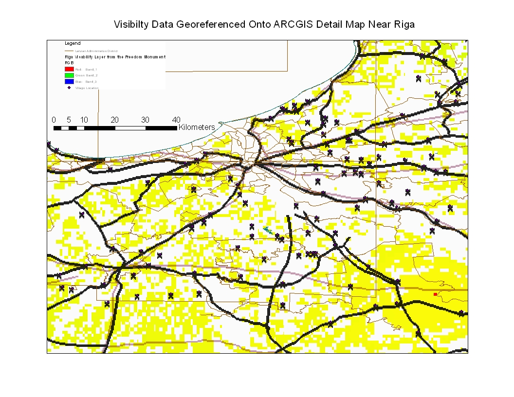
Riga Visibility Data Georeferenced Unto ARCGIS Riga Detail Map

In the map below, I took the visibility data from the Freedom Monument observation and georeferenced it to a more detailed ARCGIS map of the Riga region.  The results indicate that the visibility detail is not so concentrated when georeferenced into a more detailed observation map.  The yellow squares indicates that for the detail that is available, the visibility deta generated in GRASS 6.4.1 shows that the Riga region is relatively flat and that not considering buildings, visibility taking height into consideration from the top of the Freedom Monument is very great.  The X's are villages, some of which was used for georeferencing.  This is only an experiement, folks.