Dear Visitors:

Please scroll down the page to see present and archive blogs.

Thank you very much: Tramway Null(0)

Webrings - Maps - Trolleys and More

Navigation by WebRing.
Showing posts with label New York Subway. Show all posts

Wednesday, December 20, 2017

How to Calculate Distances between Subway Stations Using ARCGIS and QGIS


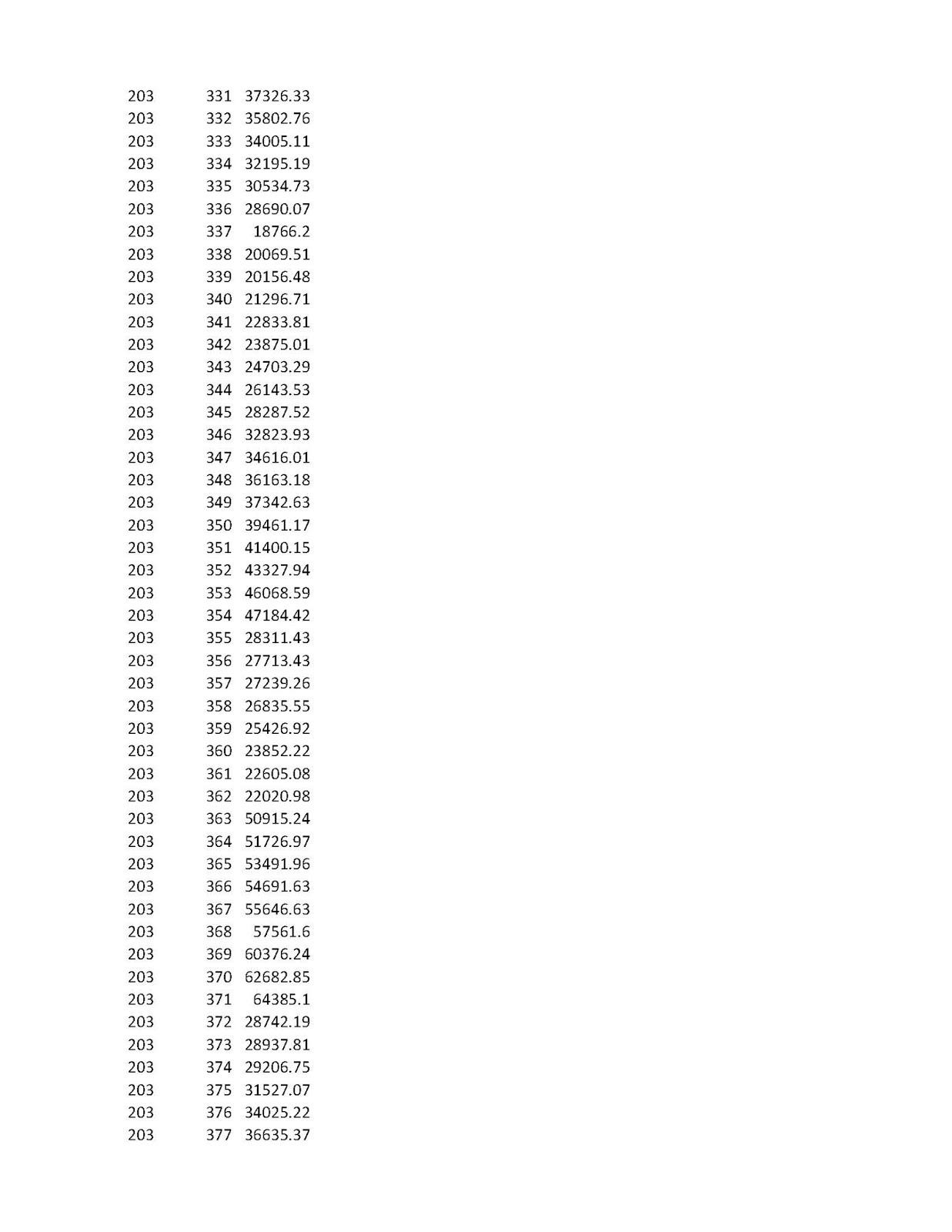
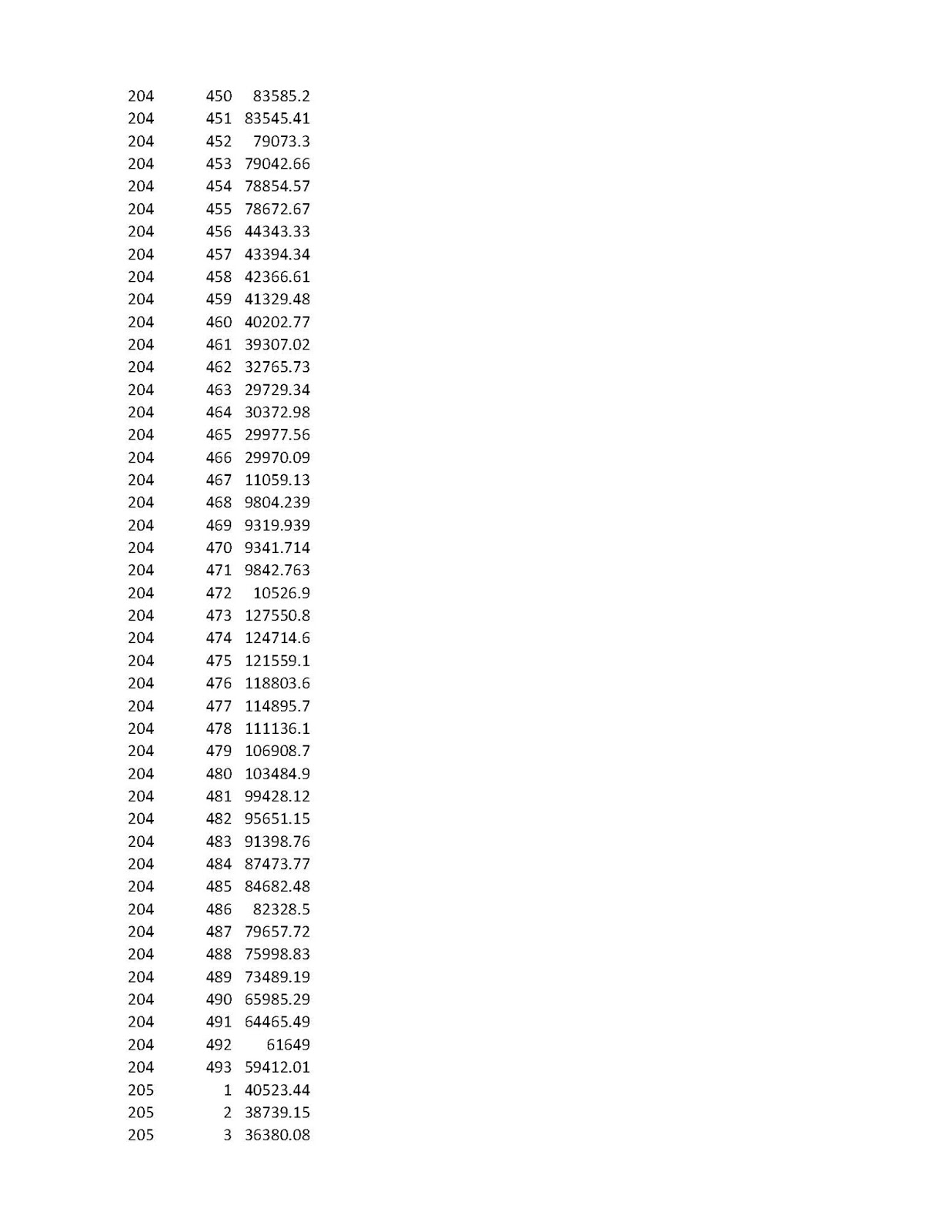
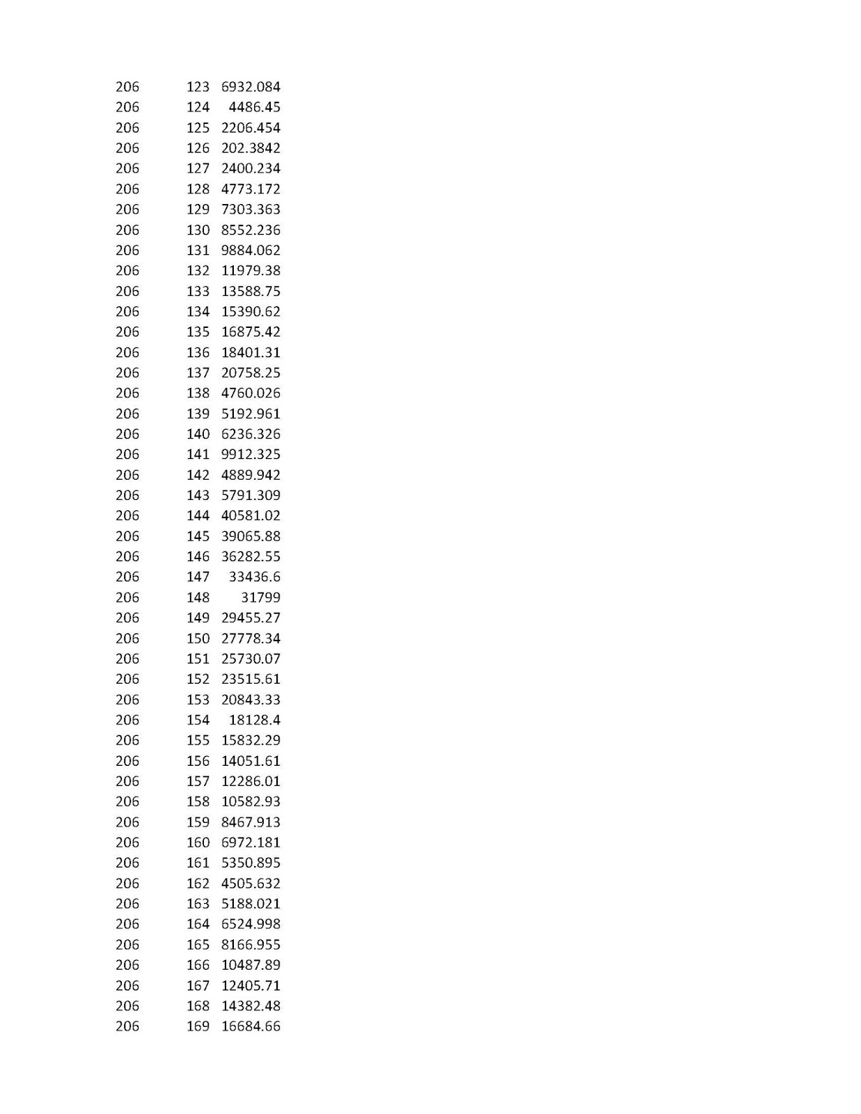
  In this exercise, we will try to develop a matrx of distances between all subway stations, including Staten Island Rapid Transit.  You may do so for your own system that you are interested in.    Thus, if we are interested in the new Second Avenue Subway Station at 96th Street and Second Avenue ( my reference number 205 ), we can observe the distance to the 71 St. Forest Hills Station ( Reference Number 427 ).    From the chart, we can see that it is 36,457.72 feet, or 6.90487 miles.  I only did this analysis for the new Second Avenue Stations ( 203 to 205 Serial Numbers).  Thus the 96 th Street Station has 493 distances to all the other stations.  This is a large amount of material to post on a log and I am not giving you the serial numbers of all stations.   Let me know if you need them.

At any rate, I hope to show you how to do this soon.

To start, you need a mapping program and a shape (*.shp) file.  ARCGIS is a big mapping program but it not free.  QGIS is a free open source software for maps.   Download a shape file for your subway stop locations.   If you want to see the line itself, (subway lines), you will need to download a shape file of the subway line.  This analysis will use only subway stops.


Once you have a shape file of subway stations, you will need to make a slight alteration to the table that lists all the subway stations.  In ARCGIS, the FID identification column begins with a zero.   Many distance tools can not read a list that has a unique serial number that begins with zero.  In ARCGIS  while in the table mode for your shapefile, create a new column.  I call mine "Newserial".  Use the field calculator to add one to the FID number:   NEWSERIAL = FID +1.   You will get a serial number that begins with 1 and you can start to do various analysis.   Incidentally, the Newserial number is the number that I use to identify the subway stations in this exercise.  If you are using ARCGIS and do not have full tool availability (Advanced Package), you will need to bring up the shape station file in QGIS.     Bring your vector station file, and then choose, vector, analyst tools and then the Distance Matrix.   The unique identifier is the serial number with no duplicates.   Choose one of the variations and make sure you designate an output file.   Let us say, the your file contains 150 stations, locations, or whatever points you are using to analyze.   You will be returned with a csv file with point 1 and 149 locations, point 2 with 149 locations until point 150 with 149 other locations.  For the New York City subway system, the number of locals is large so I could not give you all of them.   On the map, the Second Avenue Line is not shown, only the stations.  Staten Island Rapid Transit stations are also included in the analysis.  Staten Island Stations are  #493 St George to #473 Tottenville,   Far Rockaway Mott Avenue is 451 and Pelham Bay Park is 45.

Therefore, the distance between 2nd Avenue - 96 Street (Ref. 205) to Tottenville, (Ref. 473) is 130, 162.6 feet or 24.65 miles as the birds fly.

Tramway Null()

Monday, February 16, 2015

Some Thoughts from an Old Timer


Hi Folks:

   I have not posted some pictures and maps for a long time because of both hard and software problems... therefore  I would like to apologize to you all.  Currently, I am running out of ideas to post and I do not know how long I can continue this blog.  Now I would like to give you some of my biased options about the current state of affairs of transit in the New York region.

  1. Lack of Interesting New York City Subway Equipment.  Today, for both the IRT and IND-BMT divisions, in my humble opinion, the current equipment lack variety.    On the IRT subway lines, you basically have two types of equipment:  The R-62's and the R-142's, and newer R-188's.  There are two basic types and the newer equipment is similar to the R-142's which is similar to the R-160's on the BMT-IND Lines.  In the "B" division, you have the elderly R-32's which are interesting, R68's which are similar to R46's, some R-42's, and similar R143's and R-160s.  So generally speaking you have two major classes for the IRT and five on the BMT-IND, you have generally seven types of cars.  One person posted me and told me that unlike the old days, we have air conditioned cars and better signage.  This is true but system wide, there is only seven basic types.  I was told... well, in the old days, you had only three basic types:  On the IND, you had the R1-9 series, for the BMT, you had the BMT Standards and for the IRT, you had the Low-V's.  While this is somewhat true, let us pick a year and see what types of cars were around. Let us pick, the year that the Third Avenue El stopped running in Manhattan in 1955.  Generally, on the IRT, you had Low-V's  and there were some variants around.  You had the Steinways, you had old elevated equipment such as the Q types and other types.  You had the post war R-12  to R-15 types on the Flushing Line and I believe the R-17's. On the BMT, you had the BMT standards, some elevated equipment as the "C" types, you had the very different Triplexes. You had some borrowed SIRT equipment on the Culver Line.  Even the BMT standards had two classes as well with different types of roll signs and roofs.  What was interesting, is that you had some IND equipment on the BMT, such as  on the Fourth Avenue Line and you had some modified Low-V to run on the BMT around 1959.  On the IND, you had only two types, the R1-9's and the R-10's.  Some R1-9's had experimental features.  I believe the R-11 experimental cars were also around.  In short, passing and viewing a train yard was very interesting those years.  No one would mistake a Low-V interior for a BMT standard interior.  Today, the interior of IRT cars are similar to the cars on the Lettered Lines.  Yes, the current information systems on board the newer equipment is wonderful , but when the newer R160's style equipment gets old, and the same style would be copied in the future,  riding the subway would be very boring indeed because of lack of variety.  And if the equipment should be vandalized, the boring environment will not be a pleasant one, just as was in the 1970's on the IRT, where the R 17 to R -35? equipment looked alike.

Saturday, December 21, 2013

Flushing Line Front Window View Video of Extension to 34th Street

Flushing Line (#7) Extension Video.  Please find attached this news item dealing with the extension of the Flushing Line extension to 34th Street.  Although the line is not scheduled to open until 2014, the line is operational but the signals and stations are not complete.  All I can say is Wow! .  Posted originally in subchat.  This item can be used only for news services.


http://www.youtube.com/watch?v=3H6RiLzW7ng&feature=player_embedded#t=0


Some Comments:

 1. This new extension was constructed using a boring machine at great depth.  This is quite different than traditional "cut and cover" construction close to the surface.

 2.  Notice an unfinished shell of a future station.

3)  Notice the huge 34th Street station.  Why are new stations constructed so fancy and expensive?  Could a "generic station" serve its intended purpose while freeing up some money to extend the line to 23rd Street?  The tracks already extend south of the 34th street station to around West 25th Street.  In my humble opinion, having a "palace" of a station does not add more accessibility to a station than an extension does.

4)  There is no sign of the IND 42nd Street 8th Avenue Lower single track station that the line crosses as about track level at 90 degrees.  That  42nd Street lower station is now destroyed.  Perhaps if there was a link here, the IRT Flushing Line could have gone to 59th Street-Columbus Circle.  Of course there are many issues to solve, naming train width and signaling problems.


http://www.youtube.com/watch?v=3H6RiLzW7ng&feature=player_embedded#t=0

  A commenter at Subchat said that at 3:00 you can see the remains of the 42nd Street - 8 th Avenue IND Lower level station which is at right angles to the path of the train.  You can see a yellow painted pillar I believe.  The lower level 42nd Street station was the locale of some well known movies in past years.  The lower level, which is one track, saw some limited service and may have been the starting point of "Aqueduct Specials" to the racetrack, many years ago.  It is a strange station.

Tuesday, September 10, 2013

The Abandoned City Hall Loop Station as Seen by a # 6 Lexington Avenue Line Local Train

Hi Folks: I had this in my draft mode for some time. My previous post dealt with the Lexington Avenue Line track map which does show the City Hall Loop which is still in use. Now you can see the loop from the head car of a Lexington Avenue Local (Number 6) train. Thank you R-36 for the posting. Note that the beginning and ending points of this video is the historic Brooklyn Bridge Station on the IRT Lexington Avenue Line. At this location, above street level, once existed the Park Row terminal for Brooklyn elevated lines and trolley lines that crossed the Brooklyn Bridge. Near this site was the City Hall stop of the 3rd and 2nd Avenue Elevated Lines as well. and some important Manhattan streetcars terminated in the general location as well at Broadway and Park Row, not too far away.

http://www.youtube.com/watch?v=v4T85D6dgBE&feature=player_embedded


Source: Subchat posting below:

VIDEO: City Hall Loop

Posted by R36 #9346 on Wed Jan 9 18:36:09 2013
With a train with a railfan window running on the 6, it's now possible to get videos like this one. (Note, you can watch this at up to 1080p if you want.)

Friday, August 9, 2013

New York Subway Routes in Relation to Revised Hurricane Zones

The map above was produced using the old subway and subway stop shape files from several years back.  Not to much changes from year to year in New York City regarding new routes.  Currently, the Montague Street Tunnel through which the "R" train passes to Lower Manhattan is closed for 14 months due to flooding damage from Hurricane Sandy.  Even though service was restored after the storm, many of the electronic components have corroded and it was decided to close the tubes for 14 months in order to repair the damage.  At any rate, you an see that many of the subway routes passes through hurricane risk zones.  The Coney Island shop and yard is always in danger of flooding and so are many other transit facilities throughout the city.  The blue area is free from risk of hurricane damage.

Wednesday, December 26, 2012

Relative Position of New Jersey Light Rail and NY Subway and Elevations

In the map below, I brought in New Jersery Transit Light Rail Lines shape files and produced a map with New York Subway Lines and street elevations.  This map shows the relative positions of these three systems.


In the chart below, I used GEODA  (from University of Arizona) to calculate spatial position and the magnitude of New Jersey Earthquakes and the results show in this Moran's Analysis that knowing somewhat the position and magnitude of earthquake I can know it's neighbor.  Everything is spatially related.  "W-Magnitudes" is a weighted index created by spatial position.


Those readings in the upper right quadrant which are high correlates with corrected weighted index magnitudes are related to other readings in Northern New Jersey.

Each circle is one earthquake reading in NJ.

In the analysis below, more data was provided using a New Jersey elevation file.  To create the spatial join, I asked the program to assign an elevation to any quake site within 5000 feet of known contour line if available.  The multivariable Moran's I shows that there is a spatial relationship between one quake area and another and that there is a relation between quake magnitude and elevation.  In this case negative.  All this is theoretical, I am not a geologist or spatial environmental scientist. I am just playing with the programs.