

Streetcars and Spatial Analysis. What are your proposals for streetcars and or trolleybuses in Brooklyn and New York City? Here past trackage maps are presented and analyzed in todays environment. Geospatial analytical methods are discussed regarding new routes.
Showing posts with label Riga. Show all posts
Showing posts with label Riga. Show all posts
Thursday, April 25, 2013
Rainflow Direction near Riga using GRASS 6.4.1
Detail of Central Riga with Visibility Data from the Freedom Monument
In the experimental map below, I converted the elevation map of Latvia which is a raster map into a vector map with contour lines for each five meters of elevation. I magnifiied the central area as well. The yellow areas are those areas that are visible from the top of the Freedom Monument according to the GRASS 6.4.l analysis done before. A closer look will reveal that those yellow areas seem to be of higher elevations and they are "nested" showing that those areas are hills. Since many of areas have contour lines that are far apart, except for near the river, we could say that the terrain of Riga is relatively flat? In the map, railroad lines are shown in red, major roads in black and contour lines in green. The distance between contour line is 5 meters of elevation.


Tuesday, April 23, 2013
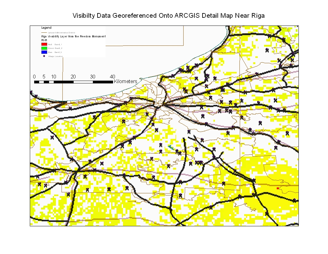
Riga Visibility Data Georeferenced Unto ARCGIS Riga Detail Map
In the map below, I took the visibility data from the Freedom Monument observation and georeferenced it to a more detailed ARCGIS map of the Riga region. The results indicate that the visibility detail is not so concentrated when georeferenced into a more detailed observation map. The yellow squares indicates that for the detail that is available, the visibility deta generated in GRASS 6.4.1 shows that the Riga region is relatively flat and that not considering buildings, visibility taking height into consideration from the top of the Freedom Monument is very great. The X's are villages, some of which was used for georeferencing. This is only an experiement, folks.

Monday, April 22, 2013
Calculating Visibilty atop Riga's Freedom Monument using GRASS 6.4.1.


Thursday, April 18, 2013
Calculating Visibility from Riga, Latvia

In my choice of x,y coordinate, I picked one at random and I am not sure if it is in the City of Riga and the height of the elevation of the observer is 1.5 meters or the height of a person A more interesting perspective would be a calculation from a point of interest, such as the top of the railroad bridge near 13 Janvara iela or other point. If someone has a nice point of interest to calculate visibility from Riga, I will nead the x, y coordinate and the height in meters.
Example: Freedom Monument, 42 Meters High, 56" 57, 24"4.Regards,
Tramway Null(0)
Wednesday, April 17, 2013
Riga Latvia Tram Route Map

http://www.lib.utexas.edu/maps/new_york.html Check out the University of Texas links to rapid transit maps on the web. You will need to scroll a bit, the link above is not direct to the rapid transit map site.
Tramway Null(0)
Wednesday, October 10, 2012
Why are Riga Tramway Trolley Poles so Long?
In another blog, an observer posted the above question. Viewing the wonderful "Riga Latvia Tramway Route 4 Video" posted earlier, I was able to see many scenes with the overhead. I am not an overhead expert, but here are some of my oberservations:
Tramway Null(0)
The picture to the right is a traditional trolleybus crossing. In Riga, this appears to be adopted for a tram - trolleybus crossing using one piece of equipment.


- When a two way streetcar crossed a trolleybus line, the overhead hardware appears to be that of one trolleybus lane crossing another trolleybus lane at right angles. Or in other words, the two tramway wires, one let us say going south and one going north join to what looks like a 180 degree trolleybus crossing. This means for one of the tram wires will be significantly out of place and needs a long pole. See "Observed in Riga Diagram". Riga has a number of trolleybus lines. In order to avoid complex tram-trolleybus overhead hardwire at crossings, see top right diagram, a simple trolleybus crossing is used where one of the tram wires is significantly shifted. In a two way tram and trolleybus crossing, instead of having four pieces of complicated overhead you only need two.
- I believe that trams that have pantographs need more complicated overhead where there is a trolleybus crossing. This is avoided using trolley pole technology. Where there is trackwork, I see that the overhead in Riga is shifted significantly.
Tramway Null(0)
The picture to the right is a traditional trolleybus crossing. In Riga, this appears to be adopted for a tram - trolleybus crossing using one piece of equipment.

Sunday, September 9, 2012
More Riga Trolleys

In this short video, you will see some shots that concentrate on the area around the Centraltirgus area of Rigas. You will see more streetcar equipment types and a commuter train that goes over the railroad bridge that you saw in the first video posted on Riga. You will get to see that mysterious underpass that looks like a subway station entrance. Riga hoped to build a Metro system but was not successful. Perhaps the underpass was a demonstation of what a future Riga subway station would look like. The city looks different in the rain and you will get to see at least the Centraltirgus (Central Market) area from a different angle.
Subscribe to:
Posts (Atom)