Dear Visitors:

Please scroll down the page to see present and archive blogs.

Thank you very much: Tramway Null(0)

Webrings - Maps - Trolleys and More

Navigation by WebRing.
Showing posts with label Visibility. Show all posts

Wednesday, August 26, 2015

More Neptune Tower and Staten Island Ferris Wheel Maps


In this GRASS 6.4.1 map dealing with visibility functions based on raster height files, the lighter blue circle on the left, which shows the visibility from the top of the proposed Ferris Wheel, touches the darker blue visibility path from the 470' proposed tower on Neptune Avenue Brooklyn.  As I was constructing these maps, I discovered that the range in meters effects the size of the circles, so the results may not be accurate. The ranges here are either the default 10,000 meters or 20, 2000 meters.

  In this map, I brought in the surface elevation in 3-D.  I also increased the range of the Neptune visibility to 50 to 60,000 meters.  Notice that the right circle appears to be bigger. It appears that on the surface, if no other buildings existed, the western shore of Brooklyn near the Narrows Bridge will have both the Ferris Wheel and the new tower visible. Notice how the elevation in northern Staten Island effects the visibility of the Ferris Wheel.

Tuesday, April 23, 2013

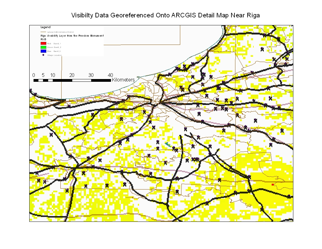
Riga Visibility Data Georeferenced Unto ARCGIS Riga Detail Map

In the map below, I took the visibility data from the Freedom Monument observation and georeferenced it to a more detailed ARCGIS map of the Riga region.  The results indicate that the visibility detail is not so concentrated when georeferenced into a more detailed observation map.  The yellow squares indicates that for the detail that is available, the visibility deta generated in GRASS 6.4.1 shows that the Riga region is relatively flat and that not considering buildings, visibility taking height into consideration from the top of the Freedom Monument is very great.  The X's are villages, some of which was used for georeferencing.  This is only an experiement, folks.

Monday, April 22, 2013

Calculating Visibilty atop Riga's Freedom Monument using GRASS 6.4.1.

  What would I see if I placed a camera atop of Riga's Freedom Monument?  Using GRASS 6.4.1. I used as an input the coordinates of 56.57 and 24.647 and I listed the height of the viewer at 42 meters, the height of the monument.  I used the default range of 100000 meters and the results are shown above.  It seems to me that most of the country would be visible?  Notice that the thin lines, which are either railroads or roads that I added as shapefiles to the map, have no images around them.  Perhaps these roads and railways are at lower elevations?  At any rate, I cannot understand the results and perhaps I did something wrong, but it was interesting to do this experiment.  Notice that for one of the pictures, I choose one with trolleybus and tram wires!  The results indicate as follows:  If I was standing atop of the Freedom Monument and if no buildings blocked my view and I was able to see the flat surface of the earth, I would see most of the yellow areas extensively into the interior and I would see higher elevations (in red) in the distance (over 150 meters high).  I would also see the island area across the water.  Of course, the buildings in Riga would block my view because this calculation was based on natural elevations only and did not take into effect the height of surrounding buildings.  The white areas would be hidden because they are low or because they are behind a high elevation area.

Thursday, April 18, 2013

Calculating Visibility from Riga, Latvia

In the map above, I used GRASS 6.4.1 to calculate visibility from the ocean near Riga.  I used coordiates 24.10, 57.07 in the projection and I set the range to 5 X 10 (6) Meters.  The result is based on the elevation file and shows a thin line of red dots along the shoreline and on a neighboring island.  This theoretically means that an observer standing at the point that the road runs perpendicular to the Ocean will find visibility to the shoreline and the ocean, but not much on shore.  This is only an experiment and I am not sure of the results; there may be an error here.

In my choice of x,y coordinate, I picked one at random and I am not sure if it is in the City of Riga and the height of the elevation of the observer is 1.5 meters or the height of a person  A more interesting perspective would be a calculation from a point of interest, such as the top of the railroad bridge near 13 Janvara iela or other point.  If someone has a nice point of interest to calculate visibility from Riga, I will nead the x, y coordinate and the height in meters.

Example:  Freedom Monument, 42 Meters High, 56" 57,  24"4.

Regards,
Tramway Null(0)

Thursday, October 11, 2012

Antenna at Former Ninth Avenue Streetcar Depot

    The former trolley depot in Park Slope Brooklyn, located between Ninth and Tenth Avenues and between 19th and 20th Streets was not only an historic depot but a huge one with two tiers.  It was active to the last day of trolley operations on October 31, 1956.  This was the beginning point of the Culver Line steam line in the 19th Century and its' location was shown on some of my posted track diagrams.  PCC research may have been conducted there in the 1930's.  Today the site is occupied by a Catholic High School that has a very tall radio transmission tower located just at the foot of McDonald Avenue.  This point is very high up on a hill and McDonald Avenue takes a plunge as it goes southward to Coney Island. It would be interesting to calculate the visibility from the top of the antenna, since the antenna is located on high ground itself.  The antenna is clearly visible from the Kings Highway elevated station on McDonald Avenue many miles to the south. Using GRASS 6.4.1, I produced a map showing the visibilty to the street surface if a person was perched on top of the antenna.  The problem is that I could not find the height of the antenna after a search on the web and I guessed that it was the same height as the Tech High School antenna at 597 feet but I may be wrong here.  The results indicate that the antenna is visible from many parts of Brooklyn and the surrounding region.  Look at the great  night photo of the antenna shown on the link below.  The former depot is at the center of the circle.  The two colored  rings indicate what street surfaces are visible from the top of the antenna using the guessed height.  Notice that the high hills of Staten Island block the view for Staten Island residents.

http://www.flickr.com/photos/maiandy/4385724367/


Wednesday, August 29, 2012

Calculating Visibility from the Smith-9th Street Station in Brooklyn using GRASS 6.4.1.

In the attached map, New York Subway station and lines were brought in to produce a map.  The street elevation level was added and GRASS 6.4.1 terrain analysis was conducted to produce the visibility to the street surface from the station itself, which is about 90 feet tall.   The x-y coordinate I used was 985286.93, 184579.87   The green area on the map shows the area, if buildings were not in the way, how far an observer will see the surface.  Of course, you can see much further than the green area if you are looking at tall buildings and other structures.  Notice that the visibility area is not circular because the surface has hills in it that would block the observer's view.


These pictures were taken off the web.  The top picture is serveral years old and shows a southbound R-46 F train approaching the Smith-9th Street after leaving the the tunnel at Carroll Street.  The second picture is also off the web and was taken from the same station and is facing north showing the Culver Viaduct declining into the Carroll Street Station.  Notice the buildings on the hill west of the viaduct.  The above picture shows the viaduct above the Gowanus Canal. The station is above the canal and runs to the right.  Notice that on the terrain analysis diagram, the hill in Carroll gardens is blocking the view of the surface (non green area) , just like in the photograph.

   In the map below, the same GRASS 6.4.1 procedure was run,  except that the range was expanded to 700,000 meters.  I do not know why the analysis stops in middle of the harbor.  The Smith-9th Street station is found on the map as a red X.