Dear Visitors:
Please scroll down the page to see present and archive blogs.
Thank you very much: Tramway Null(0)
Webrings - Maps - Trolleys and More
Tuesday, December 22, 2015
Another Close Look at the Error in the Elevation File
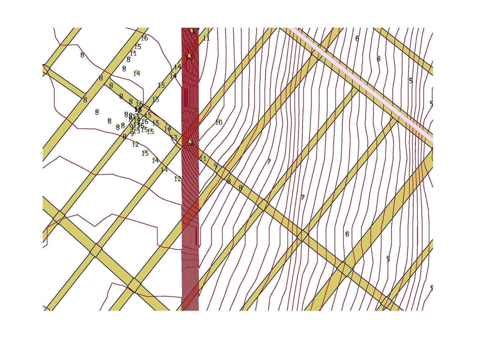
The map below was produced QGIS and includes the contour type elevation file for New York City. As shown in other posts, there appears to be a line at 90 degrees in the western part of Brooklyn. The above map is a close up and I incorporated the street grid and subway stops and lines. Notice that the red "error" line crosses close to the 20th Avenue and 86 Street station of the "D" train ( West End Line) in Brooklyn. Notice the group of contour lines to the right (east) of the red line. I cannot explain it. In the future, I will add the "add on" elevation feature to explore that area.
A street view in Google of the area reveals a relatively flat area.
In the map above, produced by QGIS, I used the plug in tool to assign an elevation at any selected point. Notice the cluster to the left of the red bar. It is at Bay 25th Street and Benson Avenue. Notice that the elevation changes from 8 feet to 15 feet on opposite sides of the intersection. The contour lines appear to be incorrect. On the right of the bar, there are many contour lines but the elevation does not change that much. Something is wrong here.
Saturday, December 19, 2015
Errors in NYC Elevation Raster File
For several years, I have been posting in this blog several postings dealing with the elevation of various parts of New York City. Some of these postings are from a raster file, which is basically a aerial photograph of a land area. It is possible, through some mapping programs, to change a raster file to a contour picture, which shows a series of lines. The closer the lines appear close together, the slope increases. For some time, I noticed in one set of posts, a straight line that is exactly at 90 degrees to the bottom of the picture. In the frame below, this line appears not at the arrow, but near the intersection of the West End (D) and Sea Beach (N) routes in Brooklyn near 62nd Street and New Utrecht Avenue. It does not appear exactly at that intersection, but parallels the West End line structure to where it curves on 86th Street and continues south to Coney Island. This line stops at the water and continues at the same angle in western Coney Island. Using QGIS, I was able to activate an interesting feature that is able to assign an elevation in a map at any particular point. It is important to note, the this plug in is not getting the elevation from my raster or contour file but probably from the internet. In the second map below, the area around 79th street and 18th Avenue is shown in Brooklyn. The red vertical bar of many lines comes from my contour file and is the error. The numbers around the bar are elevations. The vertical red bar crosses either 18 or 19th Avenue at this spot ( I was too lazy to put in a label in QGIS to show the exact location). Elevations in the bar show no abnormalities in elevation. A street view inside the "bar"shows no major changes in elevation or structures such as a sunken highway or elevated tracks. So what is it? Probably an aerial photograph that was not joined together probably causing a "seam". The last map shows the "seam in black and white". Notice that it looks like a rapid transit line.
Friday, December 11, 2015
Philadelphia: A Transit Treasure with Gas Tanks.
Philadelphia, a historic city that is not too far away from New York is a transit treasure. It has a subway and elevated lines, traditional streetcars, a streetcar subway, interurban style streetcar operations with trolley wire and third rail, and a large commuter rail system. Philadelphia, like New York, did get rid most of its streetcar lines, but the trolley subway may have played a roll in saving some lines. The Girard Avenue line was reconstructed and is currently PCC car equipped. Some traditional streetcar routes, such as #23 Germantown Avenue are now bus operated even though SEPTA told that this bustitution would be temporary. I am told that in Northern Philadelphia, some wire is still up and some track segments remain. Philadelphia has also three trolley bus routes in North Philadelphia that are still running, but the two abandoned routes in South Philadelphia (Snyder and Tasker Morris) still have wire up.
I used Google to take a tour of the Snyder Avenue Line. I punched in at random an address on Snyder Avenue and I got the following shot:
This is at the western end of the line. I believe that the route turns on 29th Street. This is a one way loop with wire still up. What do I see in the background,.... is that a gas tank?
I started to follow the street but the street ends and there is an expressway and the river with a name that is hard to pronounce. Somehow, I Googled across the river to Passyunk, which is a historic town and near S. Newkirk Avenue, there is a baby gas tank, at least as of a few years ago. Incidentally, the trackless trolley wire on Snyder is in bad shape. I am not sure when the line was abandoned "temporarily". From other sources, unfortunately, the trackless trolleys are difficult to operate and SEPTA is not to happy with electric surface transit, as I glean from subchat.
Sorry for the quality of the pictures. The gas tank and its lattice support is probably large because it was visible from the trackless trolley loop which is quite far away. More to follow on Philadelphia.
Below is a recent news study about Philadelphia transit.
https://www.google.com/url?
sa=t&rct=j&q=&esrc=s&source=newssearch&cd=1&cad=rja&uact=8&ved=0ahUKEwjRkuOHi9zJAhVBOz4KHbYFANEQqQIIHCgAMAA&url=http%3A%2F%2Fwww.philly.com%2Fphilly%2Fbusiness%2F20151213_Hed_W_Initial_Caps.html&usg=AFQjCNHR_vtb2JbsP-JRUX6YvGn0fRrLqw&sig2=bndVPckRrLskrGcVC7TcOQ&bvm=bv.109910813,d.cWw
Saturday, December 5, 2015
GeoReferencing a 1766 Red Hook and Downtown Brooklyn Map
Hi Folks:
I came across an interesting web site that deals with some of the material found here but in a more historical fashion. It is called Ephemeral New York https://ephemeralnewyork.wordpress.com/.
I came across an interesting map from that site. I was not able to get the source but it seems to be an early map of the City of Brooklyn in 1766-7. At that time, what is now the borough of Brooklyn, consisted of a number of small towns, some dating back to early Dutch settlement. Then, the town of Brooklyn was around the area nearest Manhattan (New York) and consisted of the area of present day downtown Brooklyn and Red Hook. The map was truncated so I could not get the names of the owners in the legend.
This is the map posted in Ephemeral New York. There does not appear to be many streets except the "Road to Flatbush" and the "Road to Jamaica", which were towns further to the east on Long Island. The road to Flatbush probably became Flatbush Avenue and the other road to Jamaica may have become "Fulton Street". These road split as shown on the map and will become an important point to georeference using ARCGIS. It is interesting to note that on this map, surveyed in the years 1766 and 1767, elevation was taken into account on what appears to be hills. On this map, the hills appear to be brown and have a contour appearance, like a modern contour map.
Using Adobe, I transfered the above map from a xxx file into a TIFF file, which is a raster file in ARCGIS. Using a modern street grid of Brooklyn ( from Bytes of the Big Apple), I started the georeferencing process. Notice from the old map the the coast line is not the same as we have today. Apparently, there have been much landfill in the past 250 years. Acting very fast, I did no research on the points listed on the map to get a more accurate overlay, but I did use one point on the old map where the road to Flatbush splits off from the road to Jamaica. This is the Flatbush Fulton Street intersection. The modern streets today may not be in the exact location shown on the map 250 years ago. I also picked a point near Wallabout Bay and crossed referenced it on a modern map since the shape of the coastline appears the same. I also picked an arbitrary point on Governours Island as well.
Notice how the resultant georefeneced map is distorted. In the base ARCGIS map, I brought in the modern subway system and stop file and the street grid. The results are not perfect but shows on the 1766 map where the modern street grid may fall, perhaps.
I noticed that the "hill" areas on the 1766 map appear somewhat accurate. One way to test this is to bring in a modern contour map and see if the concentration of contour lines really correspond to a hill on the 1766 map.
In this frame above, the hilly areas are show by a concentration of dark lines. It is hard to see the original hill drawings on the 1766 map so I lightened the contour lines by changing the display percentage.
Generally the increase in slope shown by the contour lines on the modern map corresponds to the hilly areas shown on the 1766 map, even after 250 years of development on the surface.
Although not shown on the subway map above, but the street elevation at Bergen and Smith Streets is 24 feet ( this will need to be verified ). This station may have had a water condition that resulted in the closing of the lower level (Express) platforms. This area may have been adjacent to the Gowanas Canal but the elevation is high. This will be discussed later. Thanks folks: Tramway null (0).
Tuesday, December 1, 2015
A Selection of Maps Made Using QGIS
I revisited QGIS again, that GRASS related geo-spatial software. It is possible to bring in previously created or used raster and vector files into that environment. There are many advanced features that I did not try yet, that the no-frills ARCGIS software does not supply. In QGIS, you can take a raster file and make contours; something that you cannot do in ARCGIS without buying a more expensive package.
In this QGIS map, a NYC raster file was brought in and converted to contours. A vector subway map (stations, lines and RR's) was also added. The arrow points to the area between the Culver and Brighton Lines in Brooklyn along the Bay Ridge RR cut/ The map is able to show the open cut (change of the elevation) around the area. The contour lines are very crisp and easy to produce.
A closer map of the area. The arrow points to the location where the Culver Line on McDonald Avenue passes over the Bay Ridge Cut at "Stop and Shop". Produced in QGIS using Bytes of the Big Apple and other sources.
This interesting map was produced using recent NYC flood zone information, the street grid for Staten Island and a contour map produced in QGIS from a NYC Elevation raster file. I was surprised to see that the RR for the northern shore of Staten Island at this point is more inland as one goes west. These three maps were produced using QGIS, is a free online software.
Sunday, November 29, 2015
We hear a lot about football coaches, but how about Trolley Coaches?
Tomorrow in France I believe a big conference will be held dealing with the environment and climate change. Transportation will be discussed. I hope they consider, what is called the "Transit's Stepchild", namely the "trolley coach" as part of a solution to surface transportation pollution.
This picture was taken from www.nycsubway.org and was taken on 4/18/59 by George Contrad. It shows a BMT work train with AB Standard Cars on the elevated portion that approaches the Williamsburgh Bridge in Brooklyn on the Jamaica Line. Several trolley coaches are shown as as well. If you look closely under the el, you may spot a twin shrunken street lamp as well. What a great picture.
Sunday, November 22, 2015
Where the New World Trade Center Stands Now
This photograph comes from the New York Public Library Archive and is probably from 6/1/37 at Greenwich and Courtland Streets in Manhattan. The New York Public Library has a nice digital archive for New York City and this photo comes up when you click a dot that is located near the footprint of the former World Trade Center. Lower Manhattan for centuries was made up of narrow streets and small blocks with multi-story buildings. Under urban renewal, the old streets and buildings we redeveloped into what is called "super blocks". It is hard to believe that nothing in this photo exists today. In the 1930's, streetcars in Manhattan started to be converted to bus and to make work, the Work Progress Administration started to remove the trolley tracks. Notice the conduit track which is typical for Manhattan street railways. The Ninth Avenue Elevated probably stopped service a few years later on 6-1-40. The new Eight Avenue subway, opened nearby in the early 1930's, with stations in the area at Broadway-Nassau (Fulton Street), Chambers Street (at Church Street) and Hudson Terminal (on Church Street near the present site of the World Trade Center at Vesey Street. the northern border of the former World Trade Center. The IRT 7th Avenue Line passes directly through the site at Greenwich Street, I believe the same street shown above. Many parts of New York City do not look like what existed 70 years ago and I think everything in the picture does not exist now. I believe that the area used to be called "radio row" because of all the electronics shops that existed then. The area called TRIBECA, which is on the west side of Manhattan above Chambers Street is very fashionable now but as late as of the 1960's, that area has a lot of lofts and the shoe industry was located there.
The next photo comes from the same archive and is dated 7/1/33 by P.L. Sperr. It is a the intersection of Fulton and Greenwich Streets and is facing west towards the Hudson River.
From this photo, you can see that Greenwich Street had the Ninth Avenue El and the IRT 7th Avenue Broadway line as well (see the subway entrance with the two globes). This intersection is well within the WTC present complex and does not exist today.
Subscribe to:
Posts (Atom)