

Streetcars and Spatial Analysis. What are your proposals for streetcars and or trolleybuses in Brooklyn and New York City? Here past trackage maps are presented and analyzed in todays environment. Geospatial analytical methods are discussed regarding new routes.
Thursday, June 28, 2012
1924 Aerial of section of the 5th Avenue and Fulton Street Els in Brooklyn
1924 Aerial of Gravesend Race Track Pathway with recent Building Footprint

Monday, June 25, 2012
Video of the West End Trolley and Church Avenue Trolley Tunnel
Since in my last posts the subject was the West End Trolley (1916-1947), I found this video showing the 25th Avenue Loop at Harway Avenue. In 1946, the West End trolley was cut back to this loop instead of going to Coney Island. The private right of way is also shown just to the east of New Utrecht Avenue between 81st Streets and 84th Street. The B.M.T. West End Line is shown in the background. Today, Sixth Avenue "D" trains run on this elevated\subway route. Two PCC cars are shown and this must have been a promotion for the New York's World's Fair. Some other interesting views are shown, including a trolley emerging from the trolley tunnel under Ocean Parkway.
https://www.google.com/url?url=http://www.youtube.com/watch%3Fv%3D1WvRSZSoktA&rct=j&sa=X&ei=En7mT8yZIIrJ0QHTqYHyCQ&ved=0CGMQuAIwAzgU&q=trolley+videos+brooklyn&usg=AFQjCNGJosiCQxkqXPBV2OUaCfNxyzrSjw
https://www.google.com/url?url=http://www.youtube.com/watch%3Fv%3D1WvRSZSoktA&rct=j&sa=X&ei=En7mT8yZIIrJ0QHTqYHyCQ&ved=0CGMQuAIwAzgU&q=trolley+videos+brooklyn&usg=AFQjCNGJosiCQxkqXPBV2OUaCfNxyzrSjw
Wednesday, June 20, 2012
West End Line - South Portion Until 1916

This track map shows the layout during the days that 5th Avenue - West End Elevated trains ran on the surface in this part of Brooklyn. Motive power for this section was overhead trolley. Not shown on this map, but on the north section map, motive power from around 36th Street and 5th Avenue station and north to the Brooklyn Bridge was third rail power.
Tuesday, June 19, 2012
West End Line North Section Until 1916
Source: Watson, Edward B. & Linder, B. New York Division Bulletin, Vol 22, No. 6, June, 1979, p5.
 This track diagram refers to the operation of elevated trains using trolley wire on the surface. Third rail power started, I believe near the 36th Street - Fifth Avenue station and north to the Brooklyn Bridge.
The Bay 19th Street Private Right of Way is featured in one of the videos that I posted about Brooklyn Trolleys. A more complete narrative may follow in the future. Southern section to follow in a future post.

The Bay 19th Street Private Right of Way is featured in one of the videos that I posted about Brooklyn Trolleys. A more complete narrative may follow in the future. Southern section to follow in a future post.
Monday, June 18, 2012
West End Trolley (Brooklyn) 1916-1947
Source: Watson, Edward B. & Linder, B. New York Division Bulletin, Vol. 22, No. 6, June, 1979, pp.2-5.
 Since in a prior post, I showed videos of Brooklyn trolleys, some of which showed 39th Street Street and New Utrecht Avenue and Bay 19th Street, it is appropriate that I should show the streetcar line that ran at these locations. The West End trolley, started its' life as a steam railroad line in 1864 and went through a similar progression as its' sister slightly to the east, the Culver Line. The progression was: Steam Railroad on the surface, electric elevated trains with trolley poles on the surface, steel structure with elevated /subway trains and trolley cars on the surface. Like its' sister, the McDonald Avenue Trolley, the West End Trolley ended its' life (1947) even without the indignity of being replaced by a "stink buggy", also known as a diesel bus.

Friday, June 15, 2012
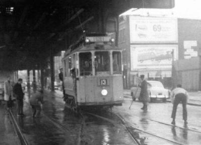
Gothenburg Trolley # 79 on McDonald Avenue near Avenue I on 4/16/61

Source: Trolley Museum of New York, Item Number 5774, Used with permission.
The shot, taken on 4/16/61 is at the same spot where a previous post shows a PCC car passing a South Brooklyn RR diesel a few years earlier. It is hard to believe that almost six years after city owned trolley service stopped in Brooklyn and ten months after the last trolley bus ran on July 27, 1960, the overhead wire on McDonald Avenue was still charged. The last trolley over the Queensborough Bridge ran in 1957. This European car I believe is presently is in the New York Trolley Museum in Kingston and dates back to the early 20th Century. This car run was a special event I believe was organized by the Electric Railway Association. After this picture was taken, the South Brooklyn Rail Road sent a letter to the Transit Authority on December 27, 1961 ordering that the TA should de-energize the overhead (B. Linder, New York Division Bulletin, Vol. 19, No. 2, Part 8, page 4, April, 1976). Complete removal of poles, overhead and other equipment between Fort Hamilton Parkway and the Coney Island Freight yard was accomplished by November 19, 1965. Branford Electric Railway got an agreement to remove the remaining overhead between Fourth Avenue and New York Bay.
. Other trolley runs in Brooklyn after this date, I have been told, was an experiment in the Coney Island Yard in 1968 using a section of overhead that was still intact and was recharged by connecting it to a third rail power source. Other trolley runs were for move shots and of course, experiments by Bob Diamond in Red Hook on the waterfront.
After trolley service stopped on McDonald Avenue on October 31, 1956, the only electric vehicles running there was electric locomotives pulling freight cars. After studing a report dated January 7, 1958 estimating that it would cost $32,000 to rehabilitate the trolley wire and trough on McDonald Avenue (B. Linder, op. cit.), South Brooklyn decided to pull the plug on electric trolley freight service and decided that two second hand diesels were sufficient for motive power. Although $32,000 does not appear expensive today for a government agency, it was a lot a money in 1958.
Probably if the system remained intact after repairs, movie shots today may have brought in more than $32,000 per year in taxes and fees.
In the section of the South Brooklyn Railway that you see above between the Fourth Avenue Tunnel and Coney Island, in 1961 averaged 70 loaded cars in and two cars out monthly. In October and November 1961, South Brooklyn handled 60 carloads of grapes, which was one-fourth of the tonnage handled in 1920 (B. Linder, op.cit.).
Monday, June 11, 2012
A Selection of Brooklyn Trolley Videos
http://www.youtube.com/watch?v=T116yHKoUTs&feature=relmfu
The first video above is labeled "Church Avenue" but it really shows the B-68 Coney Island Avenue Trolley at Park Circle and along Prospect Park West and Southwest. It may show also the B-69 McDonald Vanderbuilt line. There is a great shot of Partel Prichard Square and the Sands Theatre. Modern PCC and older equipment is shown.
http://www.youtube.com/watch?v=xdGKbTHpMcg&feature=relmfu
This is a great video showing the Church Avenue Line at Argyle Road. If you want to see action with Brooklyn's first trolley coach line, you will also see the Cortelyou Road trolley bus cross McDonald Avenue and you will see old and new equipment on the McDonald-Church trolley line. The trolley coaches shown are from the prior generation of coaches used from the 1930s to 1948 which were replaced by St. Louis Car Company Trolley Coaches in 1948. You will also see the McDonald Avenue trolley just meet the Culver Line El structure at the Ditmas Avenue station and where the trolley trackage meets the PRW trackage of the South Brooklyn Railway. You will catch a few nanosecond glipse of South Brooklyn Electric Locomotive action under the 13th Avenue Station at 37th Street and Church Avenue. You will also visit the New Utrecht and 39th Street intersection and if you look closely, you will see the turnout for the West End trolley. And last but not least, various equipment going into and leaving the Ocean Parkway Trolley Tunnel is presented.
http://www.youtube.com/watch?feature=player_detailpage&v=_qigy5CTZx4
This video covers the Coney Island area when Coney Island was Coney Island. You will see Luna Park and other Amusement Parks when Coney Island was an international resort. Today it is a meer shadow of itself. You will see trolley action on Surf Avenue with Sea Gate cars and other action at Neptune Avenue. You will catch a glipse of the upper tier of the elevated structure (Brighton Line) between West 8th Street and Stillwell Avenue subway stations.
http://www.youtube.com/watch?v=un3o9SkUInY&feature=player_detailpage
Here is featured little known streetcar lines, such a the West End Trolley and the Norton's Point Line running in their own private rights of way. The West End Trolley had its PRW near Bay 19 th Street and the Coney Island Norton's Point Line ran over an incline to the Stillwell Avenue subway station. This is one of the few places were a streetcar in Brooklyn was on elevated structure. Other places were at the approach to the Brooklyn Bridge and at the end of the 3rd Avenue El at 65th Street in Brooklyn.
http://www.youtube.com/watch?v=XQDbJha1jqc&feature=player_detailpage
Downtown Brooklyn is shown here on Jay Street. Also is shown the public display of the then new PCC streetcar in Albee Square in 1936. See the Fulton Street Elevated Line above.
http://www.youtube.com/watch?v=1WvRSZSoktA&feature=player_detailpage
Here you will see something very unusual. The West End Trolley ran under the BMT West End Line for most of its route but it also ran on a private right of way. Since it was not a busy line, it did not sport the best equipment. Here, two PCC streetcars are shown on the Bay 19th Street PRW which is apparently part of a promotion for PCC service to the New York World's Fair in 1939. I'm not sure about this, but BMT Lines wanted to charge passengers a extra nickle for the fare (a total of 10 cents) and Mayor LaGuardia who not have any part of this and the PCC service to the World's Fair lasted one day only. I'm not sure about the starting point of this special World's Fair service, but it was probably not along the West End Trolley.
http://www.youtube.com/watch?v=2VO5uC1nbQ8&feature=player_detailpage
Shows the present day subway station at Essex Street off the Williamsburg Bridge and also shows the darkened former trolley terminal next to the Brooklyn bound subway track.
Friday, June 8, 2012
Grand Street Line (Manhattan) 1931 - Another Line that crossed the Williamsburg Bridge
Source: B. Linder, New York Division, Electric Railroaders' Association, The Bulletin, Vol. 44, No. 12, December, 2001. Pages 2-4.
 Since we were on the topic of the Williamsburg Bridge, here is another conduit line that crossed the bridge and went to Bridge Plaza in Brooklyn. According to B, Linder, ownership of the line by the Dry Dock, East Broadway & Battery Rail Road Company started on April 17, 1860, but the actual starting date is not known. Using a well known guide (Bullinger's Monitor Guide), Linder was able to establish that by 1869, horse cars started to operate from Grand Street ferry to the Desbrosses Street ferry on the Hudson River. The last day of horse car service was August 2, 1905 and various sections of the line became electrified by conduit in stages. By November 28, 1905, an additional branch from Desbrosses Street Ferry to Bridge Plaza in Brooklyn was opened. Brooklyn service was discontinued on January 21, 1932 and September 3, 1932 was the last day of streetcar service. The next day buses started over the same route but not going to Brooklyn. I wonder if a Brooklyn - Desbrosses Street Line would be popular today. Many 19th Century streetcar lines in Brooklyn and Manhattan serviced ferry terminals. The Grand Street Line, when it started enabled a Brooklyn passenger to eventually reach New Jersey. It is interesting that today, if the line existed, it would serve two fashionable areas, SOHO and Williamburg and its surroundings.

Tuesday, June 5, 2012
Experiments With Trolley Trucks (Siemen's eHighway concepts)

http://www.youtube.com/watch?feature=player_embedded&v=kMev1FCMQLU
http://www.youtube.com/watch?v=u93-k83EPiI&feature=player_detailpage
http://www.youtube.com/watch?v=yPQwjolnYDI&feature=player_embedded
http://www.youtube.com/watch?v=HG76DcXySuw&feature=player_detailpage
Please see the demonstation video above.
Folks: Look what I ran across from "Trolleymotion" accidentally! Siemens is doing experiments with trolley trucks. If highways get trolley wires for trucks, perhaps intercity trolley buses can use the same overhead and this will encourage trolleybus use. Also, Swedish videos provided showing historic trolley trucks of the past. All of this will come in handy if peak oil is reached.
Please take a look.
Tramway Null(0)
Monday, June 4, 2012
Delancey Street Trolley Terminal - Part II


When constructed, the Williamsburg Bridge consisted of two separate vehicular roadways on the north and south sides of bridge and between the roadways were two sets of separate trolley tracks (four in all) that were separated by a two track elevated line. The northerly set of trolley tracks were used by Manhattan streetcars using conduit trackage. These cars ran from several starting points in Manhattan, such as the Post Office Line at Park Row and ended at the Brooklyn plaza of the bridge. The southerly tracks were used by several Brooklyn trolley lines using overhead. Since the Essex Street station did not open until 1908, for five years Brooklyn trolleys ended at a stub just east of Clinton Street on the bridge near the entrance. According to Rogoff (1958), there was a double crossover and a single track connection to Manhattan trolleys on Delancey Street.
Regarding elevated trains, Brooklyn Rapid Transit elevated trains running on Broadway (Brooklyn) did not use the bridge until 1908 when the Essex Street station opened. Prior to this, elevated trains used a terminal at the foot of the East River which was the location of a East River ferry. When the Essex Street station opened in 1908, it was a stub terminal with two tracks with a center platform and two side platforms. If you visit the station today, it looks a little out of alignment because it presently has three tracks with a center platform and one side platform for southbound trains coming off the bridge. According to Rogoff, this station was built in 1908 with wide roof columns for future simple reconfiguration in case the line expanded, which it did. Along the "elevated" train terminal at Essex Street is the huge trolley terminal for Brooklyn trolleys which I described in earlier post. This terminal also opened in 1908? and closed in 1950. The trolley terminal trackage was never connected to the subway\elevated trackage. Currently, there are plans to convert this former trolley terminal into a underground park space. In my humble opinion, since the "L" train is overcrowded and many districts in eastern Brooklyn have experienced recent population increases, a study should be made to see if trolleys going over the Williamsburg Bridge from different communities that have poor rapid transit coverage to the Delancey Street trolley terminal would be a help.
Tramway Null(0)
Friday, June 1, 2012
145 Street Crosstown (1919) run by New York Railways
Source: B. Linder, "145th Street Crosstown", New York Division Bulletin, Vol. 30, Number 9, September, 1987, Page 5.
 The map shown above does not show the Bronx trackage for this route that also ran on 145th Street. The Bronx trackage ran east and I captured some of it in the 1924 aerial previously posted. The aerial does not show the street trackage extending to Southern Boulevard in the Bronx.
Important facts are as follows:
The information shown above comes from the source sited, but it is not clear from the description for the Third Avenue Railway Company if cars ran from Broadway and 145 Street to Lenox and another branch from 181 Street and Broadway to Amsterdam Avenue and 145th Street and across 145th Street to Lenox Avenue. The Broadway and 145th Street description may be a mistake for 181st Street cars.. Also map does not show Bronx trackage.
Tramway Null(0)

Important facts are as follows:
- Line started on November 1, 1905 by the Metropolitan Street Railway Company.
- Line ran on 145th Street from Broadway to Lenox Avenue.
- On August 5, 1912, the Third Avenue Railway Company started to operate the 149th Street Crosstown from Broadway and 145th Street, bridge, 149th Street in the Bronx to Southern Boulevard.
- On April 9, 1915, the Third Avenue Railway Company started operating from Broadway and 145th Street from 181st Street via Broadway, St. Nicholas Avenue, Amsterdam Avenue, and 145th Street and Lenox Avenue.
- On July 11, 1920, New York Railways discontinued the 145th Street Crosstown, but Third Avenue Railway operated streetcars until they were replaced by buses in 1947.
The information shown above comes from the source sited, but it is not clear from the description for the Third Avenue Railway Company if cars ran from Broadway and 145 Street to Lenox and another branch from 181 Street and Broadway to Amsterdam Avenue and 145th Street and across 145th Street to Lenox Avenue. The Broadway and 145th Street description may be a mistake for 181st Street cars.. Also map does not show Bronx trackage.
Tramway Null(0)
Subscribe to:
Posts (Atom)