

Streetcars and Spatial Analysis. What are your proposals for streetcars and or trolleybuses in Brooklyn and New York City? Here past trackage maps are presented and analyzed in todays environment. Geospatial analytical methods are discussed regarding new routes.
Friday, February 28, 2014
Area Around Pelham Bay Park Today
In the ARCGIS map attached, I brought in some railroad shape files and some other files dealing with subway routes, bus routes from 2008 and an elevation contour file. You can see the approximate location where the Bartow Station on the New Haven Railroad was located. Much land fill and development took place over the last 100 years, including the development of Co-Op City. The area between the New England Thruway and the Hutchinson River Parkway used to be "Freedomland", many decades ago. "Freedomland" was an amusement area and I saw someplace, and I cannot prove it, there were plans to bring a trolley with overhead wires to the area. Of course, nothing came of this plan. Other parts of the area was used as a New York City Sanitation Department landfill which produced a small "hill". You can also see the "Dyre Avenue Line" that tookover the right of way of an interesting past railroad operation.
Wednesday, February 26, 2014
The Pelham Bay Monorail
Source: Linder, B. "Pelham Park Railroad Company" in New York Division Bulletin, Electric Railroaders' Association, Vol. 38, No. 8, August, 1995, pp 2-3. Map is by the Electric Railroaders' Association but it is marked "December, 1944, Electric Railroads". Map presented to ERA by Francis J. Goldsmith with other documents.
Many people do not know that the City Island - Pelham Bay Park area had a monorail from approximately July 17, 1910 (one trip only because the car derailed) and from October 1910 to March 16, 1914 between the Bartow station of the New Haven Rail Road and Marshall's Corner at the entrance to City Island. Original service to City Island was by horsecar but was eventually replaced by battery cars. Streetcar service to City Island ceased on August 9, 1919 and was replaced by buses Horsecars were still operating when the monorail stopped running. Battery cars operated from August 17, 1914 to August 9, 1919. Although the map does not show actual City Island streetcar trackage, it does shown other interesting features such as the railroads that ran through the area and other Bronx trolleys. I believe the horsecar and then battery car route was from the Bartow Station to the trip of City Island.
Please see this interesting map below. Other comments will follow in the future.
A drawing from the same source shows a view of the monorail from three angles. Notice that the "monorail" was on the bottom of the car attached to ties. Two brackets supported the car from above and the power source was in the middle. Since the support structure was low, it would have made it difficult for crossing traffic, both road and electric transit. I believe that the advantage of this monorail was that it was able to handle uneven surfaces but it would make it difficult for crossing traffic.
A picture is below:
What is ironic is that City Island is very near to Co-Op City, which is a vast multi-story housing development in the Northeast Bronx. Co-op City opened in stages around the year 1971 and the newsletter from the development at that time stated "...the monorail from the subway to Co-Op City is 'just around the corner'...". In all the years that have past, no new extension to the IRT Pelham Bay Park Line was ever built, nor was any light rail. There are plans to utilize the New Haven Railroad that runs at the east margin of Co-Op City by opening a station perhaps at the same location discussed in the map and other locations in the east and south Bronx, thus providing additional rapid transit access to the east and south Bronx to Grand Central Station. I am not sure if there were any plans involving Light Rail for Co-Op City. In addition, and I am not sure of this, the Independent Subway (second system) was supposed to reach the area around Co-Op City by going along Burke Avenue east from the 205th Street area in the north Bronx.
Wednesday, February 19, 2014
Tram Tunnel in Kraków
Hi Folks:
I came across this video of a tramway line in Krakow that has some subway right of way. Take a look at the tunnel (non station) section and tell me if you never saw a neater, cleaner section of tunnel. It looks like an office building hallway with straight walls and nice doors to utilities. Of course, the stations are beautiful and so are the trams.


See the video below for a clearer look at the subway tunnel.
Below is a picture of the Dworzec Glowny or Glowny (Head or Main) Train Station.
Sorry that I did not place in the correct Polish spelling; Przepraszam.
http://www.youtube.com/watch?feature=player_detailpage&v=1P7fFdohywY
In some respects, this video is similar to the one that I posted about the Volgograd Tram subway which also starts on the surface along a Private Right of Way and goes down a long incline to a neat looking subway tunnel.

I came across this video of a tramway line in Krakow that has some subway right of way. Take a look at the tunnel (non station) section and tell me if you never saw a neater, cleaner section of tunnel. It looks like an office building hallway with straight walls and nice doors to utilities. Of course, the stations are beautiful and so are the trams.
See the video below for a clearer look at the subway tunnel.
Below is a picture of the Dworzec Glowny or Glowny (Head or Main) Train Station.
Sorry that I did not place in the correct Polish spelling; Przepraszam.
http://www.youtube.com/watch?feature=player_detailpage&v=1P7fFdohywY
In some respects, this video is similar to the one that I posted about the Volgograd Tram subway which also starts on the surface along a Private Right of Way and goes down a long incline to a neat looking subway tunnel.
Tuesday, February 18, 2014
Let me Vent a Little: The BMT Fourth Avenue Subway and its' Vent Vaults
Hi Folks:
The Fourth Avenue Subway that runs along Fourth Avenue in Brooklyn south of the historic Williamsburgh Bank building is a busy line that predates the Independent Subway by many years. Today, the D, N and R routes provide service but when I was a child, other names were used to describe the service: West End Express, West End Location, Sea Beach Express, Culver Express and Culver Local and the local of locals, the Fourth Avenue Local. Interesting equipment such as the three car articulated "D" types were on the Sea Beach and on the occasional West End Express. The Fourth Avenue Local had the BMT standards and some borrowed IND R1-9 types. The Culver Line
and West End Local usually ran BMT standards and in later years, a modified IRT Lo-V and some SIRT BMT look alike cars. Most of you "youngsters" probably do not know, that the Fourth Avenue Subway until around 1960 had a different "look" to it in that between south of Pacific Street to south of 36th Street Stations the express tracks were exposed to tremendous amount of light from the air vents above. So much light was provided, that a passenger in a Fourth Avenue local sitting on the side of the express tracks would be able to see that it was raining outside because the wooden protection boards were wet. It was very bright for whole sections with the sunlight streaming in. This dance of sunlight against the wall went very well with the special music that the Triplex Type D cars produced on the Sea Beach Express as it speeded along Fourth Avenue. Today, a passenger can see a slightly paler shade of concrete along the wall that separates the express tracks below the current air vents.
It would have been nice that any redesign of Fourth Avenue would bring natural light into the subway as in days of old.
Currently, there is some discussion to modify Fourth Avenue in terms of width, the width of the central island and car turns. I believe, a few years ago, Fourth Avenue was supposed to be redesigned due to the new residential construction along the avenue.

A post card showing Fourth Avenue around 1905-7 before the subway was built. At 53rd Street and Fourth Avenue.
 The next series shows a more modern Fourth Avenue. The above picture is probably from 1959 perhaps after the center island was made narrower.

Slightly larger vents, perhaps before being made narrower.
 You can see that most of the island is taken up by the vent, thus letting much light and air into the subway. Later vents were higher up and narrower.
 Notice that the island appears to be higher over here. The Williamsburgh Bank Building is in the center.
 This image was produced by Google Maps by pointing to 22 Street and Fourth Avenue Brooklyn. Notice how narrow this divider is. I do not know if this is recent construction.

The Fourth Avenue Subway that runs along Fourth Avenue in Brooklyn south of the historic Williamsburgh Bank building is a busy line that predates the Independent Subway by many years. Today, the D, N and R routes provide service but when I was a child, other names were used to describe the service: West End Express, West End Location, Sea Beach Express, Culver Express and Culver Local and the local of locals, the Fourth Avenue Local. Interesting equipment such as the three car articulated "D" types were on the Sea Beach and on the occasional West End Express. The Fourth Avenue Local had the BMT standards and some borrowed IND R1-9 types. The Culver Line
and West End Local usually ran BMT standards and in later years, a modified IRT Lo-V and some SIRT BMT look alike cars. Most of you "youngsters" probably do not know, that the Fourth Avenue Subway until around 1960 had a different "look" to it in that between south of Pacific Street to south of 36th Street Stations the express tracks were exposed to tremendous amount of light from the air vents above. So much light was provided, that a passenger in a Fourth Avenue local sitting on the side of the express tracks would be able to see that it was raining outside because the wooden protection boards were wet. It was very bright for whole sections with the sunlight streaming in. This dance of sunlight against the wall went very well with the special music that the Triplex Type D cars produced on the Sea Beach Express as it speeded along Fourth Avenue. Today, a passenger can see a slightly paler shade of concrete along the wall that separates the express tracks below the current air vents.
It would have been nice that any redesign of Fourth Avenue would bring natural light into the subway as in days of old.
Does any old timer remember the lighted vent vaults between Pacific and 36th Street?
What was the situation between 36 th Street and 86 th Street?
Currently, there is some discussion to modify Fourth Avenue in terms of width, the width of the central island and car turns. I believe, a few years ago, Fourth Avenue was supposed to be redesigned due to the new residential construction along the avenue.
A post card showing Fourth Avenue around 1905-7 before the subway was built. At 53rd Street and Fourth Avenue.
Slightly larger vents, perhaps before being made narrower.
Thursday, February 13, 2014
Sparky
The link below was presented in subchat today. As you know, the United States is having a harsh winter, including here in New York, with rain, snow and sleet. This posting, from 2003 shows a New York subway train in the third track of an elevated line running to clear the tracks during or after a blizzard. What a light show!
As a child, I remember the Culver Shuttle that had one track and no protection boards over the third rail. What a show during the 1969 "Lindsay" blizzard! The sky really lights up!
Since trolleys were destroyed in New York when I was young, I never remembered a light show produced by an ice storm and I have no experience of being during an ice storm in a city that has much trolleybus and streetcar lines. What is like to experience an ice storm in Riga, Warsaw, Moscow, or any other city that has a big electric surface transit coverage? It must be beautiful.
Tuesday, February 11, 2014
Shirley Temple Passes Away Today
Please see video below taken in 1937 in Los Angeles where Shirley Temple inaugurates service on the new 1937 PCC Streetcars. I believe I saw this clip in 1977 on TV on the 40th Anniversary of this
ceremony. Thanks to the internet, it is available. In the 1950's to 1980's, when rapid transit became unpopular in the United States, would you have even thought that a child star would dedicate a new subway car or system? It was just not fashionable or hip during those years, at least in the United States.
In this second video, which shows the end of streetcars in Los Angeles in 1963, I think you can see the same PCC car (#3002) dedicated by Shirley Temple in 1937. It is indicated by writing on the streetcar and the number 3002..

Friday, February 7, 2014
Rare Map of the New York, Westchester and Boston Railway
Source: Linder, B., " The Westchester's Last Days" in The Bulletin, Electric Railroaders' Association, Vol. 56, No.1, January, 2013, p. 7,8. Drawing of Map is from Marvin L. Landsman, et. al. Electric Railroaders' Association, May, 1962.

 The New York, Westchester and Boston Railway, which ran in Bronx and Westchester counties ended service after midnight on December 31, 1937 as a result of the Great Depression. Many books have been written on the subject. My experience with the line is riding the IRT Dyre Avenue Line in the Bronx which took over part of the right of way (see map) on May 15, 1941 as a shuttle line. (Present Day IRT Number 5 Route). Much of the right of way north of the Bronx has been taken over by roads and general development. I came across the map which was republished in "The Bulletin" and I thought it would be interesting to post. The railroad was built according to high standards and I did not believe how extensive the coverage. Notice that the end of line was Harlem River where there was a transfer to the Third Avenue Line. We covered the area mentioned earlier in the blog. Users of the NY, Westchester and Boston did not have a one seat ride to the "city ". Perhaps if the NY, Westchester and Boston traveled up the ramp to the Third Avenue El station at 133 Street, where a cross platform transfer could have been arranged, or through service provided from Westchester, the histories of both railways (El and NY, Westchester and Boston), would have been different.
Monday, February 3, 2014
Some Brooklyn Trolley Overhead Artifacts
Readers of this blog know that many times the topic of interest in this blog is the last days of trolley operation, both streetcar and trolleybus in Brooklyn. Streetcar service ended in Brooklyn in 1956 and trolleybus service in 1960. For many years after abandonment, entire section of wire and poles remained standing, but surely over the past decades, nothing almost remains. Yes, there are a few poles around in various parts of Brooklyn, specially near many BMT rapid transit facilities. I mentioned the horizontal span wire segments along the incline of the "F" route Culver Line south of Ditmas Avenue. Here is a close up generated by Google Maps:
The view is facing south east along McDonald Avenue. Notice the green girder with the horizontal insulator and a few inches of span wire. Former southbound McDonald and McDonald-Church trolleys ran southbound along this wall. In the incline are four IND subway tracks joining the Culver Elevated south of Ditmas Avenue. I believe that the incline was built sometime between 1933 and the late 40's. This green girder has been holding the span wire and segment for a very long time!
Another area of focus was the trolley turn on the waterfront for the Church and Eighth Avenue trolleys at 39th Street near First Avenue. Some poles remain and is that the original span wire? There appears to be two "clamps" for the power cables at the right position.
 Notice the "span" wire between the two poles. The attachments to the poles do not look original but look at the span wire and what appears to be small clamps. I believe the view is west towards New Jersey. This is the present turnaround loop for the B-35 Church Avenue Bus.
Another area that is interesting is near the 62nd Street - New Utrecht Avenue intersection. Here you had everything: 1) Sea Beach Express Line in open cut (N train today),
2) West End Line on Elevated Structure (Present Day D train).
3) West End Trolley under the el on New Utrecht Avenue and
4) LIRR passenger and freight using electric overhead (at least during the freight days) to the mid sixties and now consists of one track that is diesel operated in open cut slightly to the side, and
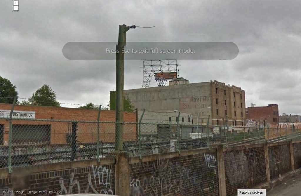
5) Trolleybus # 23 turnaround (Cortelyou Road Trolleybus) from roughly 1932? to October 31, 1956. The poles from the turnaround for the trolleybus operation and probably date from 1932. The second pole was hidden behind a tree so I did not include it in the picture.
 The view is southwest towards New Utrecht Avenue. You are facing the 62nd Street station of the BMT West End Line. The concrete building is the entrance to the joint entrance area for both the Sea Beach (N) and West End (D) trains. You can see the walkway to the elevated station to the right of the picture. Due to budget cuts, the B-23 Cortelyou Road bus has been cut from service for several years already. It is interesting to note that the line was important enough in the 1930's to be tested with the first trolleybus operation in Brooklyn. Other areas with trolley overhead artifacts can be found, but they are getting fewer and fewer.
The view is facing south east along McDonald Avenue. Notice the green girder with the horizontal insulator and a few inches of span wire. Former southbound McDonald and McDonald-Church trolleys ran southbound along this wall. In the incline are four IND subway tracks joining the Culver Elevated south of Ditmas Avenue. I believe that the incline was built sometime between 1933 and the late 40's. This green girder has been holding the span wire and segment for a very long time!
Another area of focus was the trolley turn on the waterfront for the Church and Eighth Avenue trolleys at 39th Street near First Avenue. Some poles remain and is that the original span wire? There appears to be two "clamps" for the power cables at the right position.
Another area that is interesting is near the 62nd Street - New Utrecht Avenue intersection. Here you had everything: 1) Sea Beach Express Line in open cut (N train today),
2) West End Line on Elevated Structure (Present Day D train).
3) West End Trolley under the el on New Utrecht Avenue and
4) LIRR passenger and freight using electric overhead (at least during the freight days) to the mid sixties and now consists of one track that is diesel operated in open cut slightly to the side, and
5) Trolleybus # 23 turnaround (Cortelyou Road Trolleybus) from roughly 1932? to October 31, 1956. The poles from the turnaround for the trolleybus operation and probably date from 1932. The second pole was hidden behind a tree so I did not include it in the picture.
Subscribe to:
Comments (Atom)